IMAGES TAKEN NEAR TO
Dunstan Village, ALNWICK, NE66 3TE
Introduction
This page details the photographs taken nearby to Dunstan Village, NE66 3TE by members of the Geograph project.
The Geograph project started in 2005 with the aim of publishing, organising and preserving representative images for every square kilometre of Great Britain, Ireland and the Isle of Man.

There are currently over 7.5m images from over14,400 individuals and you can help contribute to the project by visiting https://www.geograph.org.uk
Image Map
Images are licensed for reuse under creativecommons.org/licenses/by-sa/2.0
Notes
- Clicking on the map will re-center to the selected point.
- The higher the marker number, the further away the image location is from the centre of the postcode.
Image Listing (53 Images Found)
Images are licensed for reuse under creativecommons.org/licenses/by-sa/2.0
Image
Details
Distance
1
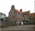
Dunstan Hall
Pevsner describes this as 'a quite small but very complex house'. The tower marked on the OS map isn't visible from this angle, but this east wing of the main house is certainly very old and is most likely 14thC.
Image: © Gordon Hatton
Taken: 24 Oct 2014
0.03 miles
2
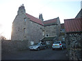
Peel tower at Dunstan Hall
The hall is a Grade II* listed building http://www.britishlistedbuildings.co.uk/en-236938-dunstan-hall-craster- which incorporates a fortified tower. It is available for hire as a holiday cottage (useful if any marauding Scots are in the area).
Image: © Karl and Ali
Taken: 28 Dec 2013
0.06 miles
3
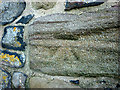
Cut bench mark at Proctors Stead
In an eroded state due to the softness of the sandstone. At an altitude of 37.501m asl.
Image: © Karl and Ali
Taken: 28 Dec 2013
0.07 miles
4
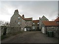
Dunstan Hall (Craster)
Dunstan Hall probably has its origins in the 13th century as a hall house, possibly built of timber on stone footings. In about 1310 the main block was rebuilt in stone. The Scots burned down the house in 1385 and it was again rebuilt and a turret added. In the 16th century the building was remodelled with the main part of the building raised and a staircase turret added. The building was remodelled again in the mid-17th century and this time reduced in height. In 1706 the north wing was added and the interior was altered. A porch was added in 1831 and in 1938 more alterations were made and the, then ruined, north range was rebuilt. The hall does not seem ever to have been a truly defensive building. This is a Grade II* Listed Building protected by law.
http://www.keystothepast.info/article/10339/Site-Details?PRN=N5839
Image: © Les Hull
Taken: 4 Mar 2020
0.07 miles
5
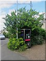
Public telephone box, Dunstan
The public telephone box in the small village of Dunstan.
Image: © Graham Robson
Taken: 31 Aug 2013
0.07 miles
6
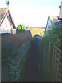
Footpath between houses, Dunstan
A narrowly enclosed footpath down to the Craster road.
Image: © Karl and Ali
Taken: 28 Dec 2013
0.08 miles
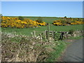
8
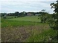
Proctor's Stead
View of a farm and fields at Dunstan, from the lane from Dunstan Square.
Image: © Peter Barr
Taken: 20 Jun 2011
0.09 miles
9
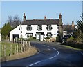
A house in Dunstan
A cosy village a kilometre from Craster and the sea with a comfortable and welcoming inn.
Image: © Russel Wills
Taken: 30 Jan 2015
0.09 miles
10
Footpath to Dunstan Square
Off National Cycle Route 1.
Image: © JThomas
Taken: 30 Apr 2015
0.09 miles