IMAGES TAKEN NEAR TO
Denwick View, ALNWICK, NE66 2PZ
Introduction
This page details the photographs taken nearby to Denwick View, NE66 2PZ by members of the Geograph project.
The Geograph project started in 2005 with the aim of publishing, organising and preserving representative images for every square kilometre of Great Britain, Ireland and the Isle of Man.

There are currently over 7.5m images from over14,400 individuals and you can help contribute to the project by visiting https://www.geograph.org.uk
Image Map
Images are licensed for reuse under creativecommons.org/licenses/by-sa/2.0
Notes
- Clicking on the map will re-center to the selected point.
- The higher the marker number, the further away the image location is from the centre of the postcode.
Image Listing (50 Images Found)
Images are licensed for reuse under creativecommons.org/licenses/by-sa/2.0
Image
Details
Distance
1
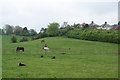
Horses on the edge of Alnwick
The houses at the top are on West Acres which is one of the older residential roads.
Image: © Bill Boaden
Taken: 20 May 2013
0.11 miles
2
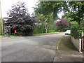
West Acres, Alnwick
Looking along West Acres from its junction with Alnmouth Road. A public telephone box and post box are located adjacently on the left side of the road. The telegraph pole has an obvious lean.
Image: © Graham Robson
Taken: 9 Aug 2014
0.12 miles
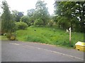
3
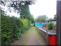
Start of footpath
From Alnmouth Road, this footpath runs to Allerburn Lea see Image
Image: © Michael Dibb
Taken: 23 May 2011
0.13 miles
4
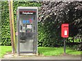
Post box and telephone box, West Acres, Alnwick
A post box and public telephone box stand beside a leaning telegraph pole on West Acres close to the junction with Alnmouth Road.
Image: © Graham Robson
Taken: 9 Aug 2014
0.13 miles
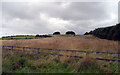
5
To Alnmouth road
From this section of Allerburn Lea, this footpath runs to Alnmouth Road (see Image).
Image: © Michael Dibb
Taken: 23 May 2011
0.13 miles
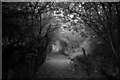
8
![Urban path [1]](https://s1.geograph.org.uk/geophotos/02/46/08/2460813_e23b9de8_120x120.jpg)
Urban path [1]
As the footpath reaches the edge of the housing estate, it becomes enclosed.
Image: © Michael Dibb
Taken: 23 May 2011
0.15 miles
9
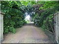
Driveway to Freelands
The driveway leads to Freelands, a grade II listed Georgian House.
Image: © Michael Dibb
Taken: 23 May 2011
0.15 miles
10
![Urban path [2]](https://s3.geograph.org.uk/geophotos/02/46/08/2460815_dc2a9810_120x120.jpg)
Urban path [2]
The footpath passes through a tunnel of greenery as it makes its way between two streets of recent houses.
Image: © Michael Dibb
Taken: 23 May 2011
0.15 miles