IMAGES TAKEN NEAR TO
Lower Barresdale, ALNWICK, NE66 1DW
Introduction
This page details the photographs taken nearby to Lower Barresdale, NE66 1DW by members of the Geograph project.
The Geograph project started in 2005 with the aim of publishing, organising and preserving representative images for every square kilometre of Great Britain, Ireland and the Isle of Man.

There are currently over 7.5m images from over14,400 individuals and you can help contribute to the project by visiting https://www.geograph.org.uk
Image Map
Images are licensed for reuse under creativecommons.org/licenses/by-sa/2.0
Notes
- Clicking on the map will re-center to the selected point.
- The higher the marker number, the further away the image location is from the centre of the postcode.
Image Listing (43 Images Found)
Images are licensed for reuse under creativecommons.org/licenses/by-sa/2.0
Image
Details
Distance
1
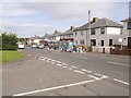
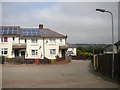
Houses on Lower Barresdale
The rear of what once will have been council houses on the outskirts of Alnwick.
A public footpath follows the fence line.
Image: © Trevor Littlewood
Taken: 9 Mar 2023
0.02 miles
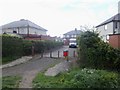
2
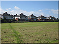
Rear of semi detached houses on Lower Barresdale, Alnwick
A row of semi detached houses, part of a former council housing estate, face on to this large sports field.
Image: © Graham Robson
Taken: 28 Aug 2012
0.07 miles
3
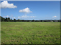
Football pitches, Alnwick
A pair of football pitches are located on this large open space behind a housing estate.
Image: © Graham Robson
Taken: 28 Aug 2012
0.09 miles
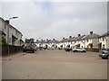
5
Housing estate
The bridleway passes the corner of a large housing estate. The street is Lower Barresdale.
Image: © Michael Dibb
Taken: 28 May 2011
0.12 miles
6
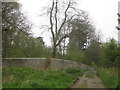
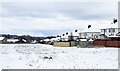
Gate and Wall
The wall marks the boundary of Hulne Park.
Image: © Jonathan Thacker
Taken: 21 May 2012
0.13 miles
7
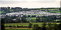
Alnwick
Housing estate above Alnwick.
Image: © Peter McDermott
Taken: 30 Dec 2011
0.14 miles
9
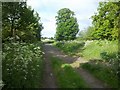
Path leaves the bridleway
The bridleway carries on to the left whilst a footpath branches off to the right. The footpath runs as far as the radar 'golfball' at Brizlee Wood.
Image: © Michael Dibb
Taken: 28 May 2011
0.14 miles