IMAGES TAKEN NEAR TO
Lindisfarne Road, ALNWICK, NE66 1AU
Introduction
This page details the photographs taken nearby to Lindisfarne Road, NE66 1AU by members of the Geograph project.
The Geograph project started in 2005 with the aim of publishing, organising and preserving representative images for every square kilometre of Great Britain, Ireland and the Isle of Man.

There are currently over 7.5m images from over14,400 individuals and you can help contribute to the project by visiting https://www.geograph.org.uk
Image Map
Images are licensed for reuse under creativecommons.org/licenses/by-sa/2.0
Notes
- Clicking on the map will re-center to the selected point.
- The higher the marker number, the further away the image location is from the centre of the postcode.
Image Listing (50 Images Found)
Images are licensed for reuse under creativecommons.org/licenses/by-sa/2.0
Image
Details
Distance
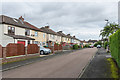
1

Lindisfarne Road
1930s housing off Swansfield Park Road.
Image: © Ian Capper
Taken: 19 Aug 2019
0.05 miles
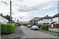
2
St George's Crescent
1930s housing in a crescent off Lindisfarne Road.
Image: © Ian Capper
Taken: 19 Aug 2019
0.05 miles
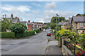
3
Lindisfarne Road
1930s housing off Swansfield Park Road. In the background is Alnwick Adult Learning Centre, housed in the buildings of the former Lindisfarne County Middle School, which closed in 2017 (previously the Alnwick County Secondary Modern School).
Image: © Ian Capper
Taken: 19 Aug 2019
0.06 miles
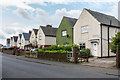
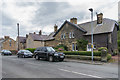
4

Swansfield Park Road
Turn of the 19th/20th Century housing.
Image: © Ian Capper
Taken: 19 Aug 2019
0.08 miles
5

Swansfield Park Road
Turn of the 19th/20th Century housing.
Image: © Ian Capper
Taken: 19 Aug 2019
0.08 miles
6
Swansfield Park Road
Turn of the 19th/20th Century housing (on the right and the first house on the left) and c1930s housing (beyond the first house on the left).
Image: © Ian Capper
Taken: 19 Aug 2019
0.10 miles
7

Swansfield Park Road
Turn of the 19th/20th Century housing.
Image: © Ian Capper
Taken: 19 Aug 2019
0.10 miles
8

Swansfield Park Road
Turn of the 19th/20th Century housing.
Image: © Ian Capper
Taken: 19 Aug 2019
0.14 miles
10
Swansfield Park Road
Turn of the 19th/20th Century housing.
Image: © Ian Capper
Taken: 19 Aug 2019
0.15 miles