IMAGES TAKEN NEAR TO
Haw Hill, MORPETH, NE65 7SH
Introduction
This page details the photographs taken nearby to Haw Hill, NE65 7SH by members of the Geograph project.
The Geograph project started in 2005 with the aim of publishing, organising and preserving representative images for every square kilometre of Great Britain, Ireland and the Isle of Man.

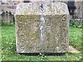
There are currently over 7.5m images from over14,400 individuals and you can help contribute to the project by visiting https://www.geograph.org.uk
Image Map
Images are licensed for reuse under creativecommons.org/licenses/by-sa/2.0
Notes
- Clicking on the map will re-center to the selected point.
- The higher the marker number, the further away the image location is from the centre of the postcode.
Image Listing (263 Images Found)
Images are licensed for reuse under creativecommons.org/licenses/by-sa/2.0
Image
Details
Distance
1
The river bank, Rothbury
Looking across the River Coquet to the north bank from Whitton Bank Road just upstream from Rothbury Bridge, The solar panel powers the adjoining street light. The green structure is a shelter.
Image: © Oliver Dixon
Taken: 31 Jul 2009
0.01 miles
2
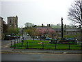
Front Street to Haw Hill, Rothbury
Taken on Front Street / High Street, Rothbury, Northumberland, to Haw Hill. All Saints Parish Church is to the left of shot.
Image: © Carroll Pierce
Taken: 12 May 2015
0.02 miles
3
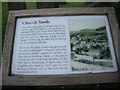
All Saints Churchyards, Rothbury
An information panel about the churchyards and some notable graves.
Image: © Stanley Howe
Taken: 21 Aug 2013
0.02 miles
4
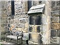
Surfeit of sundials
These two 'scratch' or 'mass' sundials (the second one is just about visible 2½ stones to the left) are on the south wall of All Saints Church. These are in addition to the 'main' one, Image
Image: © Leanmeanmo
Taken: 13 Nov 2021
0.02 miles
5
All Saints Church sundial
Clearly dated 1714 and with multiple dials, sadly missing its gnomons. This substantial block of stone has apparently been removed from its original location and now rests on the ground beside the porch. Excellent description at
https://www.pendulumpublications.com/the-rothbury-sundials.html
Image: © Leanmeanmo
Taken: 13 Nov 2021
0.03 miles
6
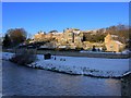
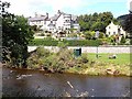
River Coquet and houses on Haw Hill, Rothbury
The top of the church tower is just above the house in the centre with the eastern part of the graveyard visible to its right. One of the bridge cut-waters can be seen bottom right.
Image: © Andrew Curtis
Taken: 6 Feb 2009
0.03 miles
8
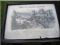
'Haa-Hill' burial ground, Rothbury
Information panel off 'The Haw'.
Image: © Stanley Howe
Taken: 21 Aug 2013
0.03 miles
9
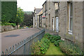
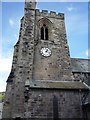
Haw Hill, Rothbury
Street running to the south of All Saint's Church.
Image: © Stephen McKay
Taken: 16 Aug 2008
0.03 miles
10
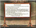
Information board on the font at Rothbury church
See Image
Image: © Derek Voller
Taken: 20 Jul 2012
0.03 miles