IMAGES TAKEN NEAR TO
Whitton, MORPETH, NE65 7RL
Introduction
This page details the photographs taken nearby to NE65 7RL by members of the Geograph project.
The Geograph project started in 2005 with the aim of publishing, organising and preserving representative images for every square kilometre of Great Britain, Ireland and the Isle of Man.

There are currently over 7.5m images from over14,400 individuals and you can help contribute to the project by visiting https://www.geograph.org.uk
Image Map
Images are licensed for reuse under creativecommons.org/licenses/by-sa/2.0
Notes
- Clicking on the map will re-center to the selected point.
- The higher the marker number, the further away the image location is from the centre of the postcode.
Image Listing (6 Images Found)
Images are licensed for reuse under creativecommons.org/licenses/by-sa/2.0
Image
Details
Distance
1
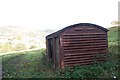
Rail wagon used as farm store/shelter. At Whitton nr Rothbury.
With Rothbury in the sunshine in the background.
Image: © David Clark
Taken: 11 Oct 2009
0.07 miles
2
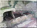
Whitton Pant
Elaborate drinking fountain and troughs. Not sure whether it's mains fed or a spring. Water tasted OK and had no smell. Grade II listed, see
https://historicengland.org.uk/listing/the-list/list-entry/1155465
Image: © Leanmeanmo
Taken: 22 Feb 2017
0.08 miles
3
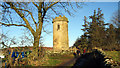
Sharpe's Tower
This tower, close to Whitton, was erected by Archdeacon Thomas Sharp in the mid 18th Century. It was used as an observatory but its main purpose was to provide work for local builders.
Image: © J C Ousby
Taken: 12 Dec 2005
0.09 miles
4
Death glide at Whitton Glebe campsite
Children enjoying themselves on the death glide at the Whitton Glebe campsite above Rothbury. In the middle distance, Coquetdale, with the Cheviot Hills beyond.
Image: © Oliver Dixon
Taken: 31 Jul 2009
0.20 miles
5
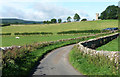
Silverton Lane, Whitton
The road curves round and down the hill to Rothbury.
The tower is Sharp's Folly, built by local vicar Archdeacon Thomas Sharp in the 1720s, it is said "partly to alleviate local unemployment and partly to satisfy the Archdeacon's taste for astronomy. Probably the earliest folly in the county." Grade II* listed.
Image: © Stephen Richards
Taken: Unknown
0.21 miles
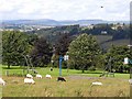
6
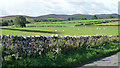
Farmland near Whitton
Sheep grazing, with the Simonside Hills on the horizon.
Image: © Stephen Richards
Taken: Unknown
0.25 miles