IMAGES TAKEN NEAR TO
Thropton, MORPETH, NE65 7JJ
Introduction
This page details the photographs taken nearby to NE65 7JJ by members of the Geograph project.
The Geograph project started in 2005 with the aim of publishing, organising and preserving representative images for every square kilometre of Great Britain, Ireland and the Isle of Man.

There are currently over 7.5m images from over14,400 individuals and you can help contribute to the project by visiting https://www.geograph.org.uk
Image Map
Images are licensed for reuse under creativecommons.org/licenses/by-sa/2.0
Notes
- Clicking on the map will re-center to the selected point.
- The higher the marker number, the further away the image location is from the centre of the postcode.
Image Listing (6 Images Found)
Images are licensed for reuse under creativecommons.org/licenses/by-sa/2.0
Image
Details
Distance
1
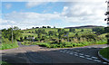
Country road near Snitter (2)
The road ahead leads north to Cartington, left leads to Snitter, right is a dead-end, and back leads to Thropton.
Mostly green and rolling country, a bit of contrast provided by the heather-topped Cartington Hill on the right.
Image: © Stephen Richards
Taken: Unknown
0.02 miles
2
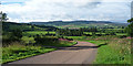
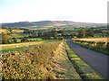
Country road near Snitter (1)
The road leads south to Thropton.
A view across Coquetdale, and the Simonside Hills on the horizon.
Image: © Stephen Richards
Taken: Unknown
0.02 miles
3
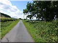
The road from South Cartington
Towards Thropton.
Image: © Russel Wills
Taken: 3 Aug 2013
0.13 miles
4
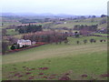
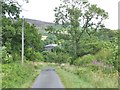
West Acre, Black Chirnells and Blue Chirnells
Three houses along the road from Thropton to Cartington, seen from a bend in a bridleway as it drops from Glitteringstone. The farm beyond Black Chirnells is Sandylands. The Cheviots in the extreme distance.
Image: © Derek Harper
Taken: 31 Dec 2006
0.16 miles
5
Looking towards Simonside Hills
Looking down the minor road from Cartington towards Thropton and Simonside Hills in the distance.
Image: © David Clark
Taken: 29 Aug 2009
0.20 miles
6
The road to South Cartington
Cartington Hill beyond.
Image: © Russel Wills
Taken: 3 Aug 2013
0.21 miles