IMAGES TAKEN NEAR TO
Harbottle, MORPETH, NE65 7BX
Introduction
This page details the photographs taken nearby to NE65 7BX by members of the Geograph project.
The Geograph project started in 2005 with the aim of publishing, organising and preserving representative images for every square kilometre of Great Britain, Ireland and the Isle of Man.

There are currently over 7.5m images from over14,400 individuals and you can help contribute to the project by visiting https://www.geograph.org.uk
Image Map
Images are licensed for reuse under creativecommons.org/licenses/by-sa/2.0
Notes
- Clicking on the map will re-center to the selected point.
- The higher the marker number, the further away the image location is from the centre of the postcode.
Image Listing (13 Images Found)
Images are licensed for reuse under creativecommons.org/licenses/by-sa/2.0
Image
Details
Distance
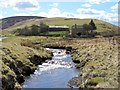
1
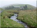
Approaching Fulhope
Where the Fulhope Burn joins the River Coquet.
Image: © Russel Wills
Taken: 30 Apr 2014
0.00 miles
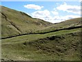
2
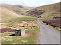
Upper Coquetdale
From the road just above Fulhope. The farm is tucked into the floor of the valley out of sight.
Image: © Oliver Dixon
Taken: 19 Apr 2009
0.03 miles
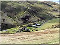
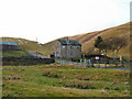
4
Fulhope, Upper Coquetdale
Fulhope is locally known as 'Philip', as it is shown on the 1866 6" OS Map, along with the 'Philip Burn' which here joins the Coquet. A 1663 account of rates and rents distinguishes 'Fair Phillips' (Halerickburne) from 'Foul Phillips'.
The OS Name Book for Alwinton (c1860) records Philip: "A small dwelling house with garden &c. attached. There is no doubt [that] this house derives its name from the 'Hill Hope' which name cannot be authenticated."
It seems perhaps more likely that the name was always Fulhope, which it had become, as had the burn (Fulhope Burn) and hill to the south-east (Fulhope Edge), by the second edition OS map (1899). The 'ful' element of the name may refer to a foul or unclean piece of land in the hope or valley, where the burn of that name joins the River Coquet.
Image: © Andrew Curtis
Taken: 19 Apr 2013
0.03 miles
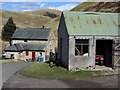
6
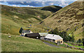
Fulhope
Fulhope Farm in Upper Coquetdale.
Image: © Peter McDermott
Taken: 12 Sep 2010
0.05 miles
7
River Coquet below Fulhope
An old poem describes the tributary streams of the River Coquet:
"First Philhope-burn (his next and near akin,
As sprung from Thirlemoor,) to his aid came in,
Then Buckham's-Walls, Blind-burn and Carles-croft streams,
Pour'd in their forces - gather'd from th' extremes
Of English ground: next Rohope's friendly flood
Joined them at Slime-foot by a winding road,
From Rohope's Fells - from whence he takes his name,
And from whose scarry sides his birth does claim.
Next Barrough-burn, whose waters many a mile
Had travell'd - from the foot of Windy-guile."
From The Marriage of the Coquet and the Alwine, published in 1817
See also Image
Image: © Andrew Curtis
Taken: 19 Apr 2013
0.09 miles
9
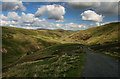
Upper Coquetdale
View looking down the valley of the River Coquet from above Fulhope.
Image: © Peter McDermott
Taken: 12 Sep 2010
0.10 miles
10
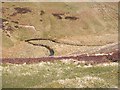
Meander in the River Coquet
A spectacular meander in the River Coquet just above Fulhope.
Image: © Oliver Dixon
Taken: 19 Apr 2009
0.12 miles