IMAGES TAKEN NEAR TO
Leslie Drive, MORPETH, NE65 0PU
Introduction
This page details the photographs taken nearby to Leslie Drive, NE65 0PU by members of the Geograph project.
The Geograph project started in 2005 with the aim of publishing, organising and preserving representative images for every square kilometre of Great Britain, Ireland and the Isle of Man.

There are currently over 7.5m images from over14,400 individuals and you can help contribute to the project by visiting https://www.geograph.org.uk
Image Map (Loading...)


Getting Data...Please wait
Leaflet Map data © OpenStreetMap
Images are licensed for reuse under creativecommons.org/licenses/by-sa/2.0
Notes
- Clicking on the map will re-center to the selected point.
- The higher the marker number, the further away the image location is from the centre of the postcode.
Image Listing (209 Images Found)
Images are licensed for reuse under creativecommons.org/licenses/by-sa/2.0
Image
Details
Distance
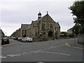
2
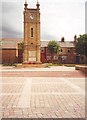
Trinity Methodist Church, Amble
This large stone built chapel, originally called Percy Street Primitive Methodist Chapel, was erected in 1902 and stands on the corner of Leslie Drive and Percy Street.
Image: © Geoff Holland
Taken: 14 Jul 2021
0.03 miles
3

Percy Street, Amble
Solid stonebuilt terrace, typical of the town centre houses.
Image: © Robert Graham
Taken: 4 Jul 2012
0.04 miles
4
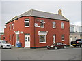
The Harbour Fish Bar in Broomhill Street Amble
Image: © Peter Robinson
Taken: 25 Oct 2012
0.05 miles
5
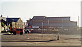
Near site of former station at Amble, 1991
The open space is near, but unfortunately not quite where, the terminus of the ex-NER branch from Chevington was situated. Actually, tracks passed the station to reach the Docks. Regular passenger services ceased from 7/7/30, but excursions came until 1939, while coal traffic to the staithes kept the branch in operation until 6/10/69.
Image: © Ben Brooksbank
Taken: 6 Sep 1991
0.09 miles
7
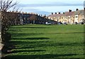
Marine Road and Panhaven Road, Amble
These two terraces close off this green at the western end of Amble Links.
Image: © Derek Harper
Taken: 2 Jan 2007
0.09 miles
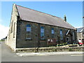
8
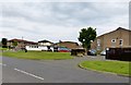
Amble Community Sports Development Centre
Formerly The Amble Boys Club. (White building to left of 'photo.Situated of the roundabout that joins Percy Drive (in front of photographer) with Percy Street and Church Street.
Image: © David Clark
Taken: 3 Jun 2014
0.10 miles
9
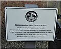
Sign board giving details of coal truck
The staithes are visible across the River Coquet from the harbour.
Image: © Russel Wills
Taken: 26 Jan 2022
0.10 miles
10
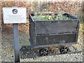
Coal truck used on the staithes
Amble grew in the nineteenth century as collieries were opened; and the newly built railway links to the Northumberland coalfields made the town a centre for the sea transport and export of coal.
The arrival of the railway lead to the construction of coal staithes.
This is an example of the trucks used on the staithes to load coal into ships.
See https://www.geograph.org.uk/photo/7080285 for details.
Image: © Russel Wills
Taken: 26 Jan 2022
0.11 miles