IMAGES TAKEN NEAR TO
Mooring Place, MORPETH, NE65 0FL
Introduction
This page details the photographs taken nearby to Mooring Place, NE65 0FL by members of the Geograph project.
The Geograph project started in 2005 with the aim of publishing, organising and preserving representative images for every square kilometre of Great Britain, Ireland and the Isle of Man.

There are currently over 7.5m images from over14,400 individuals and you can help contribute to the project by visiting https://www.geograph.org.uk
Image Map (Loading...)


Getting Data...Please wait
Leaflet Map data © OpenStreetMap
Images are licensed for reuse under creativecommons.org/licenses/by-sa/2.0
Notes
- Clicking on the map will re-center to the selected point.
- The higher the marker number, the further away the image location is from the centre of the postcode.
Image Listing (18 Images Found)
Images are licensed for reuse under creativecommons.org/licenses/by-sa/2.0
Image
Details
Distance
1
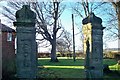
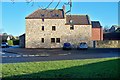
Ruins of The Old Manor House
All that is left of The old Manor House Gloster Hill. The brick property in the left background is Gloster Hill Farmhouse.
Image: © David Clark
Taken: 18 Jan 2010
0.11 miles
2
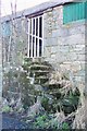
Granary steps
No longer used at the old farm buildings of Gloster Hill farm.
Image: © David Clark
Taken: 18 Jan 2010
0.12 miles
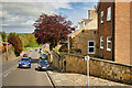
3
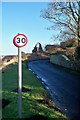
Speed limit over Gloster Hill.
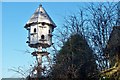
The speed limit sign on Gloster Hill, with dovecote in background.
Image: © David Clark
Taken: 18 Jan 2010
0.12 miles
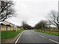
5
The Wynd, Gloster Hill, Amble
Amble is a town at the mouth of the River Coquet, on the North Sea coast of Northumberland.
Image: © David Dixon
Taken: 22 May 2021
0.17 miles
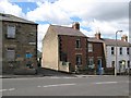
6
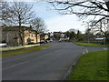
The Wynd, Amble
The main road through the village of Amble.
Image: © James Allan
Taken: 22 Feb 2017
0.18 miles
7
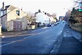
The Wynd
Leading from the Warkworth Road through town via the top end of High Street.
Image: © David Clark
Taken: 18 Jan 2010
0.19 miles
9
A dwelling converted from an older building
At the bottom of The Wynd
Image: © David Clark
Taken: 18 Jan 2010
0.19 miles
10
The top of The Wynd
The small street between the houses is Gloster Terrace and leads to the Masonic Hall. Number 22, the red brick house adjacent to Gloster Terrace was once called Myrtle House.
Image: © Adrian Taylor
Taken: 29 Jul 2007
0.20 miles