IMAGES TAKEN NEAR TO
Aged Miners Homes, NEWBIGGIN-BY-THE-SEA, NE64 6XL
Introduction
This page details the photographs taken nearby to Aged Miners Homes, NE64 6XL by members of the Geograph project.
The Geograph project started in 2005 with the aim of publishing, organising and preserving representative images for every square kilometre of Great Britain, Ireland and the Isle of Man.

There are currently over 7.5m images from over14,400 individuals and you can help contribute to the project by visiting https://www.geograph.org.uk
Image Map
Images are licensed for reuse under creativecommons.org/licenses/by-sa/2.0
Notes
- Clicking on the map will re-center to the selected point.
- The higher the marker number, the further away the image location is from the centre of the postcode.
Image Listing (57 Images Found)
Images are licensed for reuse under creativecommons.org/licenses/by-sa/2.0
Image
Details
Distance
1
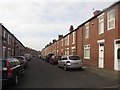
Meldon Terrace, Newbiggin-by-the-Sea
Looking along a residential street of terraced houses in Newbiggin-by-the-Sea.
Image: © Graham Robson
Taken: 13 May 2016
0.04 miles
2
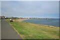
Newbiggin Bay
Looking along the length of Newbiggin Bay at Newbiggin-by-the-Sea.
Image: © Graham Robson
Taken: 13 Aug 2022
0.04 miles
3
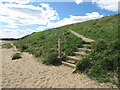
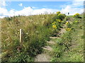
Steps, Southern End of Newbiggin Bay
These steps, which lie a handful of metres south of the lifebelt shown at https://www.geograph.org.uk/photo/6419347, eventually link up with a public footpath which runs along the cliff top, a footpath which is also the route of the England Coast Path. The England Coast Path, when completed, will be the longest waymarked and managed coastal path in the world.
Image: © Geoff Holland
Taken: 14 May 2020
0.05 miles
4
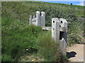
Decorative Groyne, Southern End of Newbiggin Bay
There are a handful of these decorative groynes in the small landscaped area at the southern end of the promenade including some integrated bench seating. The area provides good views to Spital Point and Spital Carrs.
Image: © Geoff Holland
Taken: 8 Jul 2020
0.05 miles
5
Steps, Southern End of Newbiggin Bay
These are the steps referred to on the sign shown at https://www.geograph.org.uk/photo/6491558 which, when followed eventually lead to a public footpath which runs along the cliff top. This public footpath follows the route of the England Coast Path which, when completed, will be the longest waymarked and managed coastal path in the world.
Image: © Geoff Holland
Taken: 3 Aug 2020
0.05 miles
6
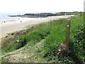
Sign, Southern End of Newbiggin Bay
This sign, which rather states the obvious, lies a short distance south of the steps shown at https://www.geograph.org.uk/photo/6473061, and, when the steps are followed, eventually lead to a public footpath which runs along the cliff top. This public footpath follows the route of the England Coast Path which, when completed, will be the longest waymarked and managed coastal path in the world. In the distance lies Spital Point.
Image: © Geoff Holland
Taken: 28 May 2020
0.05 miles
7

Lifebelt, Southern End of Newbiggin Bay
This lifebelt is attached to the railings at the extreme southern end of the promenade which runs around Newbiggin Bay. Behind, the sea breaks over Spital Carrs and on the distant horizon can be seen four of the five wind turbines making up the Blyth Offshore Demonstrator Wind Farm, which lies four miles off the coast. The 2017-completed wind farm is owned by EDF Energies Nouvelles.
Image: © Geoff Holland
Taken: 20 Mar 2020
0.06 miles
8
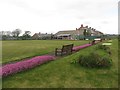
Bowls club, Newbiggin-by-the-Sea
A coastal bowls club in Newbiggin-by-the-Sea.
Image: © Graham Robson
Taken: 13 May 2016
0.06 miles
9
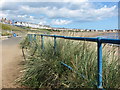
Railings, Southern End of Newbiggin Bay
These railings head towards the northern end of the bay although they do not go all the way along the promenade, the central part of which is protected by a more substantial sea wall.
Image: © Geoff Holland
Taken: 3 Aug 2020
0.07 miles
10
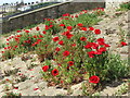
Poppies, Newbiggin Bay Promenade, Newbiggin-by-the-Sea
These poppies, which appear each year, grow in the small gaps between the decorative stones which cover this area of the steep slope lying between the promenade and the houses above.
Image: © Geoff Holland
Taken: 28 May 2020
0.07 miles