IMAGES TAKEN NEAR TO
Rydal Mount, NEWBIGGIN-BY-THE-SEA, NE64 6TJ
Introduction
This page details the photographs taken nearby to Rydal Mount, NE64 6TJ by members of the Geograph project.
The Geograph project started in 2005 with the aim of publishing, organising and preserving representative images for every square kilometre of Great Britain, Ireland and the Isle of Man.

There are currently over 7.5m images from over14,400 individuals and you can help contribute to the project by visiting https://www.geograph.org.uk
Image Map
Images are licensed for reuse under creativecommons.org/licenses/by-sa/2.0
Notes
- Clicking on the map will re-center to the selected point.
- The higher the marker number, the further away the image location is from the centre of the postcode.
Image Listing (4 Images Found)
Images are licensed for reuse under creativecommons.org/licenses/by-sa/2.0
Image
Details
Distance
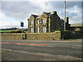
1

War Memorial
An unusual war memorial at Newbiggin by the Sea for those who fell in WW1
Image: © Christine Westerback
Taken: 4 Nov 2006
0.20 miles
2
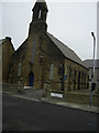
Church
St Mark's United Reformed Church Newbiggin
Image: © george hurrell
Taken: 26 Dec 2006
0.20 miles
3
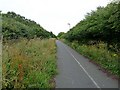
National Cycle Network route 1 at North Seaton
National Cycle Network route 1 runs from John O'Groats to Dover. Here it runs alongside the A189 (to the left), but shielded from it by a high hedgerow.
Image: © Oliver Dixon
Taken: 13 Jul 2011
0.23 miles