IMAGES TAKEN NEAR TO
Bakewell Terrace, NEWCASTLE UPON TYNE, NE6 3LE
Introduction
This page details the photographs taken nearby to Bakewell Terrace, NE6 3LE by members of the Geograph project.
The Geograph project started in 2005 with the aim of publishing, organising and preserving representative images for every square kilometre of Great Britain, Ireland and the Isle of Man.

There are currently over 7.5m images from over14,400 individuals and you can help contribute to the project by visiting https://www.geograph.org.uk
Image Map (Loading...)


Getting Data...Please wait
Leaflet Map data © OpenStreetMap
Images are licensed for reuse under creativecommons.org/licenses/by-sa/2.0
Notes
- Clicking on the map will re-center to the selected point.
- The higher the marker number, the further away the image location is from the centre of the postcode.
Image Listing (30 Images Found)
Images are licensed for reuse under creativecommons.org/licenses/by-sa/2.0
Image
Details
Distance
1
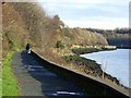
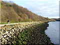
Hadrian's Way between St Peter's and St Anthony's Point
Hadrian's Way is a largely traffic-free route along the north side of the Tyne from western to eastern boundaries of the City of Newcastle-upon-Tyne. The Way is followed by both Hadrian's Wall National Trail http://www.nationaltrail.co.uk/hadrianswall/ and by route 72 of the National Cycle Network (Hadrian's Cycleway
http://www.cycle-routes.org/HADRIANSCYCLEWAY/and the Tynemouth branch of the C2C Cycle Route http://www.c2c-guide.co.uk/).
Once clear of the St Peter's Basin development, Hadrian's Way enters a remarkably rural setting.
Image: © Oliver Dixon
Taken: 18 Nov 2008
0.10 miles
5
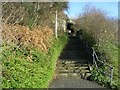
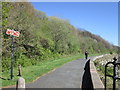
Steps up from Hadrian's Way
Hadrian's Way is a largely traffic-free route along the north side of the Tyne from western to eastern boundaries of the City of Newcastle-upon-Tyne. This flight of steps leads from Hadrian's Way where it follows a riverside promenade up to Evistones Gardens.
Image: © Oliver Dixon
Taken: 18 Nov 2008
0.12 miles
6

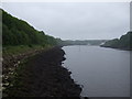
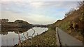
The River Tyne from St. Peter's Basin
Image: © Vicki Deritis
Taken: 28 Dec 2009
0.12 miles
7
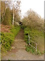
Stairs linking Hadrian's Wall Path and Hadrian's Cycleway
Image: © Anthony Foster
Taken: 11 Apr 2014
0.13 miles
8
Hadrian's Wall Path between St Anthony's and St Peter's, Walker
Image: © Chris Morgan
Taken: 30 Oct 2016
0.14 miles
10
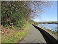
North bank of the Tyne, east of St Peter's
The promenade above the shoreline carries Hadrian's Way which is a largely traffic-free route from western to eastern boundaries of the City of Newcastle-upon-Tyne. The Way is followed by both Hadrian's Wall National Trail http://www.nationaltrail.co.uk/hadrianswall/ and by route 72 of the National Cycle Network (Hadrian's Cycleway
http://www.cycle-routes.org/HADRIANSCYCLEWAY/and the Tynemouth branch of the C2C Cycle Route http://www.c2c-guide.co.uk/).
Image: © Oliver Dixon
Taken: 18 Nov 2008
0.17 miles