IMAGES TAKEN NEAR TO
Welbeck Road, NEWCASTLE UPON TYNE, NE6 2NU
Introduction
This page details the photographs taken nearby to Welbeck Road, NE6 2NU by members of the Geograph project.
The Geograph project started in 2005 with the aim of publishing, organising and preserving representative images for every square kilometre of Great Britain, Ireland and the Isle of Man.

There are currently over 7.5m images from over14,400 individuals and you can help contribute to the project by visiting https://www.geograph.org.uk
Image Map
Images are licensed for reuse under creativecommons.org/licenses/by-sa/2.0
Notes
- Clicking on the map will re-center to the selected point.
- The higher the marker number, the further away the image location is from the centre of the postcode.
Image Listing (8 Images Found)
Images are licensed for reuse under creativecommons.org/licenses/by-sa/2.0
Image
Details
Distance
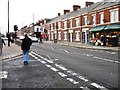
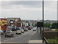
2
Welbeck Road
Main route through Walker, Newcastle-Upon-Tyne.
Image: © Stephen Sweeney
Taken: 7 Jan 2009
0.22 miles
3
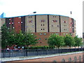
The Byker Wall
Hailed as a marvel of design, the Byker Wall was completed in 1976. Communities had their old homes demolished and were moved back into their new environment but they never recovered the community spirit they once had. The Byker Wall is now a listed building.
Image: © Christine Westerback
Taken: 13 Aug 2005
0.23 miles
4
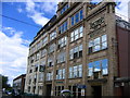
Rington's Tea Factory
Rington's still operate from this site but the lion's share of the building has been sold to an auctioneer's firm. A great building.
Image: © MSX
Taken: 11 Jul 2006
0.23 miles
5
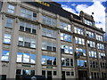
Rington's 2
Another shot of this splendid old structure.
Image: © MSX
Taken: 11 Jul 2006
0.23 miles
6
Millers Road
Leads onto Chillingham Road straddling the Metro Line.
Image: © MSX
Taken: 17 Jun 2006
0.23 miles