IMAGES TAKEN NEAR TO
Shipley Walk, NEWCASTLE UPON TYNE, NE6 2HB
Introduction
This page details the photographs taken nearby to Shipley Walk, NE6 2HB by members of the Geograph project.
The Geograph project started in 2005 with the aim of publishing, organising and preserving representative images for every square kilometre of Great Britain, Ireland and the Isle of Man.

There are currently over 7.5m images from over14,400 individuals and you can help contribute to the project by visiting https://www.geograph.org.uk
Image Map (Loading...)


Getting Data...Please wait
Leaflet Map data © OpenStreetMap
Images are licensed for reuse under creativecommons.org/licenses/by-sa/2.0
Notes
- Clicking on the map will re-center to the selected point.
- The higher the marker number, the further away the image location is from the centre of the postcode.
Image Listing (148 Images Found)
Images are licensed for reuse under creativecommons.org/licenses/by-sa/2.0
Image
Details
Distance
1

Brinkburn Street, Byker Estate
The old building at the top of the lane is Shipley Street Baths. It is integrated into the Byker Wall and was used initially to provide heating for the estate.
Image: © Andrew Curtis
Taken: 28 Mar 2010
0.05 miles
2

Byker Metro station, Tyne & Wear
Opened in 1982 by the Tyne & Wear Metro on the line from Newcastle to Tynemouth.
View east towards Chillingham Road and Tynemouth.
Image: © Nigel Thompson
Taken: 24 Mar 2012
0.05 miles


5

Parrish Court, Shields Road, Byker
Parrishes was once a good department store which declined over 40 years to the modern use of student accommodation.
Image: © Roy Douglas
Taken: Unknown
0.05 miles
6

Byker Metro - train approaching
Waiting for the train that's going to take us to the Coast
Image: © hayley green
Taken: 24 Feb 2008
0.06 miles
7

'Board Game for Byker', Byker Metro Station
'The Point of the Game is to Play' by Michael Crilly and Chris Morton (2015) is the sixth and final commission for Byker Metro station funded by Newcastle City Council, Arts Council England and Nexus, which owns and manages Metro.
Michael Crilly explained: “The work is a DaDa-ish inspired mash-up of a number of community selected video characters, board game pieces and random rules that have been relocated to a bespoke playable map of Byker and the East End of Newcastle.
“It is inspired by the architect Ralph Erskine’s inclusion of a life size chess-board into the redevelopment of the Byker estate during the 1970s, alongside communal gaming areas and hobby rooms that all remain unique to the estate.
“Like Erskine, we think that a sense of community is strengthened through encouraging social interaction and playing games together is an important part of this”
Chris added: “We have allowed residents to select their favourite avatar or playing piece and gaming rules. We have then taken the most interesting and combined these into a prototype playable board game – where the point is just to encourage people to play.”
http://www.nexus.org.uk/news/item/board-game-byker-giant-new-artwork-metro
Image: © Andrew Curtis
Taken: 20 Nov 2015
0.06 miles
8

Shields Road Bypass
View looking down Shields Road Bypass in Byker.
Image: © Peter McDermott
Taken: 23 Aug 2008
0.06 miles
9
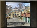
Brinkburn Close framed in doorway through Brinkburn Street terrace
Part of the Byker Wall is visible behind.
Image: © Andrew Curtis
Taken: 28 Mar 2010
0.06 miles
10

Dalton Crescent, Byker Wall
Eight-storey block in the Kendal sector.
Image: © Andrew Curtis
Taken: 28 Mar 2010
0.06 miles