IMAGES TAKEN NEAR TO
Ashington Drive, CHOPPINGTON, NE62 5EJ
Introduction
This page details the photographs taken nearby to Ashington Drive, NE62 5EJ by members of the Geograph project.
The Geograph project started in 2005 with the aim of publishing, organising and preserving representative images for every square kilometre of Great Britain, Ireland and the Isle of Man.

There are currently over 7.5m images from over14,400 individuals and you can help contribute to the project by visiting https://www.geograph.org.uk
Image Map (Loading...)


Getting Data...Please wait
Leaflet Map data © OpenStreetMap
Images are licensed for reuse under creativecommons.org/licenses/by-sa/2.0
Notes
- Clicking on the map will re-center to the selected point.
- The higher the marker number, the further away the image location is from the centre of the postcode.
Image Listing (19 Images Found)
Images are licensed for reuse under creativecommons.org/licenses/by-sa/2.0
Image
Details
Distance
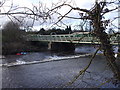
1
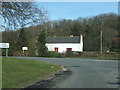
The 'White House'
Situated at the bottom of Sheepwash Bank before the bridge over the River Wansbeck.
Image: © Christine Westerback
Taken: 6 Mar 2006
0.14 miles
6
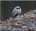
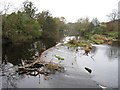
One-legged, headless heron
On the weir above Sheepwash Bridge.
Image: © Russel Wills
Taken: 5 Nov 2015
0.19 miles
7
Weir above Sheepwash Bridge
A headless heron on the left!
Image: © Russel Wills
Taken: 5 Nov 2015
0.19 miles
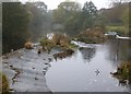
10
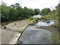
Sheepwash Weir
Looking upstream from Sheepwash Bridge. The river level in the Wansbeck is low, and is only overlapping the rim of the weir at the lower end.
Image: © Oliver Dixon
Taken: 13 Jul 2011
0.20 miles