IMAGES TAKEN NEAR TO
Ewesley, MORPETH, NE61 4LH
Introduction
This page details the photographs taken nearby to NE61 4LH by members of the Geograph project.
The Geograph project started in 2005 with the aim of publishing, organising and preserving representative images for every square kilometre of Great Britain, Ireland and the Isle of Man.

There are currently over 7.5m images from over14,400 individuals and you can help contribute to the project by visiting https://www.geograph.org.uk
Image Map (Loading...)


Getting Data...Please wait
Leaflet Map data © OpenStreetMap
Images are licensed for reuse under creativecommons.org/licenses/by-sa/2.0
Notes
- Clicking on the map will re-center to the selected point.
- The higher the marker number, the further away the image location is from the centre of the postcode.
Image Listing (11 Images Found)
Images are licensed for reuse under creativecommons.org/licenses/by-sa/2.0
Image
Details
Distance
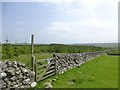
1
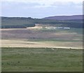
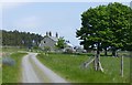
Fallowlees in Harwood Forest
Viewed from Greenleighton Hill.
Image: © Russel Wills
Taken: 4 May 2016
0.00 miles
2
St Oswald's Way approaching Fallowlees
St Oswald's Way http://www.stoswaldsway.com/home.html is a 156 Km long trail which runs from Heavenfield near Hexham to Holy Island on the Northumberland coast (although more commonly walked in the opposite direction). Here seen approaching Fallowless, a very remote farmstead set in the heart of Harwood Forest which was established in the 1950s.
Image: © Oliver Dixon
Taken: 15 Jul 2009
0.00 miles
3
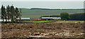
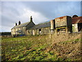
Fallowlees
Fallowlees farm in Harwood Forest.
Image: © Peter McDermott
Taken: 31 May 2008
0.01 miles
4
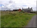
Fallowlees Farm
A remote farmstead set within Harwood Forest.
Image: © Oliver Dixon
Taken: 15 Jul 2009
0.01 miles
5
Approaching Fallowlees
At this point you could hear the sound of barking.
'If anyone is looking for a heart-warming, inspiring, funny and sometimes sad story about a year in the life of a young Northumberland shepherdess as she tries to forge a new life for herself and her dogs...' then read: ‘One Girl and Her Dogs’ by Emma Gray.
Image: © Russel Wills
Taken: 4 Jun 2016
0.01 miles
6
Fallowlees on the eastern edge of Harwood Forest
Image: © Les Hull
Taken: 12 Jan 2005
0.02 miles
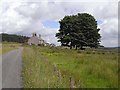
7
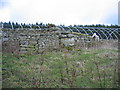
Fallowlees Bastle, remains
Keys to the Past Web Site: The remains of a post-medieval bastle stand in an isolated position at the head of the River Font. Only the north-west and south-west walls still stand, with the remaining walls only visible as foundations. The standing walls contain some original features, such as narrow, slit windows. Remains of a probable enclosure wall lie to the north.
Image: © Les Hull
Taken: 12 Jan 2005
0.02 miles
8
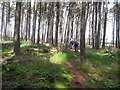
St Oswald's Way north of Fallowlees
St Oswald's Way http://www.stoswaldsway.com/home.html is a 156 Km long trail which runs from Heavenfield near Hexham to Holy Island on the Northumberland coast (although more commonly walked in the opposite direction). Here seen passing through a small patch of woodland just to the north of Fallowlees Farm within Harwood Forest.
Image: © Oliver Dixon
Taken: 15 Jul 2009
0.14 miles
9
Bridle way leaves grassland and goes into woodland
On the way from Fallowlees to Newbiggin.
Image: © Russel Wills
Taken: 4 Jun 2016
0.15 miles
10

St Oswald's Way, north of Fallowlees
St Oswald's Way http://www.stoswaldsway.com/home.html is a 156 Km long trail which runs from Heavenfield near Hexham to Holy Island on the Northumberland coast (although more commonly walked in the opposite direction). Here, the scarcely traceable path crosses a clear-felled area to the north of Fallowlees Farm in Harwood Forest.
Image: © Oliver Dixon
Taken: 15 Jul 2009
0.20 miles