IMAGES TAKEN NEAR TO
Curlew Hill, MORPETH, NE61 3SH
Introduction
This page details the photographs taken nearby to Curlew Hill, NE61 3SH by members of the Geograph project.
The Geograph project started in 2005 with the aim of publishing, organising and preserving representative images for every square kilometre of Great Britain, Ireland and the Isle of Man.

There are currently over 7.5m images from over14,400 individuals and you can help contribute to the project by visiting https://www.geograph.org.uk
Image Map
Images are licensed for reuse under creativecommons.org/licenses/by-sa/2.0
Notes
- Clicking on the map will re-center to the selected point.
- The higher the marker number, the further away the image location is from the centre of the postcode.
Image Listing (17 Images Found)
Images are licensed for reuse under creativecommons.org/licenses/by-sa/2.0
Image
Details
Distance
1
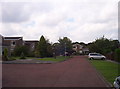
Housing
Modern housing on this estate at Grange House
Image: © Weston Beggard
Taken: 19 Aug 2006
0.09 miles
2
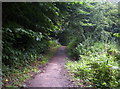
Footpath
Footpath through Scotch Gill Woods.
Image: © Weston Beggard
Taken: 19 Aug 2006
0.09 miles
3
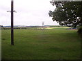
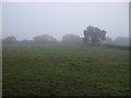
Farm Fields
Telegraph poles march across fields on West Lane End Farm.
Image: © Weston Beggard
Taken: 19 Aug 2006
0.09 miles
4
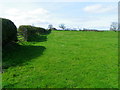
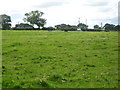
Hedge and pasture near Morpeth
It is difficult to date hedges unless there is documentary evidence as to their planting, but one theory is to count the species in a 30 metre stretch and each species counts as a century. Only count older plants and not saplings.
Many of our hedge rows have been lost in recent decades as agricultural practice favoured larger and larger fields to cultivate. There are now grants available to farmers to replant hedgerows, where before, ironically, there were grants to grub them out!
Image: © Maigheach-gheal
Taken: 7 Apr 2011
0.19 miles
5
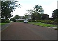
Wansdyke, another view of the street in Morpeth
Image: © James Denham
Taken: 3 Aug 2012
0.19 miles
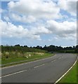
8
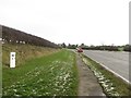
Mile post beside the A192
Looking east along the A192 towards Morpeth. The mile post Image is one mile away from Morpeth.
Image: © Graham Robson
Taken: 16 Jan 2016
0.23 miles
10
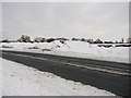
Snow mound on A192
This mound of snow/ice was the remains of the previous snow-storm. Underneath the fresh snow were the sweepings which had been piled there by the snow-ploughs but which hadn't yet melted.
Image: © Willie Duffin
Taken: 26 Dec 2010
0.23 miles