IMAGES TAKEN NEAR TO
Copperfield Drive, MORPETH, NE61 2GH
Introduction
This page details the photographs taken nearby to Copperfield Drive, NE61 2GH by members of the Geograph project.
The Geograph project started in 2005 with the aim of publishing, organising and preserving representative images for every square kilometre of Great Britain, Ireland and the Isle of Man.

There are currently over 7.5m images from over14,400 individuals and you can help contribute to the project by visiting https://www.geograph.org.uk
Image Map
Images are licensed for reuse under creativecommons.org/licenses/by-sa/2.0
Notes
- Clicking on the map will re-center to the selected point.
- The higher the marker number, the further away the image location is from the centre of the postcode.
Image Listing (12 Images Found)
Images are licensed for reuse under creativecommons.org/licenses/by-sa/2.0
Image
Details
Distance
1
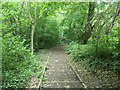
Steps in Bluebell Wood
A public footpath east of Morpeth and on the north side of the River Wansbeck.
Image: © Christine Johnstone
Taken: 18 Jul 2023
0.17 miles
3
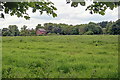
East Cottingwood
The name of a field formerly part of St Georges Hospital now managed by the Houses and Communities Agency so presumably earmarked for housing development.
The Houses and Communities Agency is a government agency but the "Private" signs are very intimidating for publicly owned land.
Image: © Mick Garratt
Taken: 1 Jun 2014
0.19 miles
4
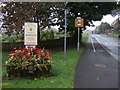
Cycle path beside the A197 entering Morpeth
Image: © JThomas
Taken: 19 Oct 2012
0.20 miles
5
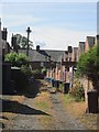
Lane, Fenwick Grove
A lane giving access to the back yards of two rows of terraced houses.
Image: © Richard Webb
Taken: 31 Jul 2012
0.21 miles
6
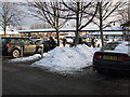
Morrison's car-park, Morpeth
Snow still lying in piles throughout the car-park making walking very difficult.
Image: © Willie Duffin
Taken: 24 Dec 2010
0.21 miles
7
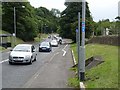
Cycle track along the A197
A cycle track has been installed alongside the busy A197 all the way from Morpeth to Ashington, designated National Cycle Route 155. Here it is seen at Dark Lane on the edge of Morpeth.
Image: © Oliver Dixon
Taken: 13 Jul 2011
0.21 miles
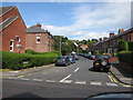
8
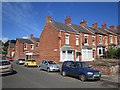
Morrison Road, Morpeth
Brick terraced houses north of the town centre.
Image: © Richard Webb
Taken: 31 Jul 2012
0.21 miles
9
Olympia Gardens, Morpeth
Situated off Howard Road.
Image: © Willie Duffin
Taken: 22 Jul 2012
0.23 miles
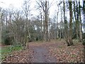
10

Path and allotments, Morpeth
A path following the River Wansbeck to the north of the town.
Image: © Jim Barton
Taken: 28 Sep 2017
0.23 miles