IMAGES TAKEN NEAR TO
River View, MORPETH, NE61 1JU
Introduction
This page details the photographs taken nearby to River View, NE61 1JU by members of the Geograph project.
The Geograph project started in 2005 with the aim of publishing, organising and preserving representative images for every square kilometre of Great Britain, Ireland and the Isle of Man.

There are currently over 7.5m images from over14,400 individuals and you can help contribute to the project by visiting https://www.geograph.org.uk
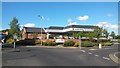
Image Map
Images are licensed for reuse under creativecommons.org/licenses/by-sa/2.0
Notes
- Clicking on the map will re-center to the selected point.
- The higher the marker number, the further away the image location is from the centre of the postcode.
Image Listing (126 Images Found)
Images are licensed for reuse under creativecommons.org/licenses/by-sa/2.0
Image
Details
Distance
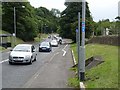
1
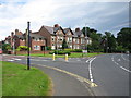
Road junction, Morpeth
Junction of Howard Street and the A197.
Image: © Willie Duffin
Taken: 22 Jul 2012
0.02 miles
2
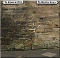
Old wooden direction signs
These superbly maintained, painted wooden direction signs must be well over 50 years old as the 'North Road' referred to was The Great North Road (A1) which used to run through the town before the construction of the Morpeth bypass.
Milestone Society National ID: NB_NZ2086
Image: © Leanmeanmo
Taken: 30 Sep 2019
0.04 miles
3
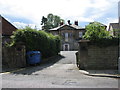
Winton House Morpeth
The Masonic Centre, Morpeth situated on Howard Road.
Image: © Willie Duffin
Taken: 22 Jul 2012
0.04 miles
4
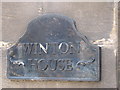
Name plaque
Name plaque on the entrance to Winton House.
Image: © Willie Duffin
Taken: 22 Jul 2012
0.04 miles
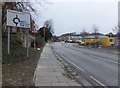
5
Cycle track along the A197
A cycle track has been installed alongside the busy A197 all the way from Morpeth to Ashington, designated National Cycle Route 155. Here it is seen at Dark Lane on the edge of Morpeth.
Image: © Oliver Dixon
Taken: 13 Jul 2011
0.05 miles
6
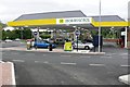
Morrisons petrol Station Morpeth
Just north west of the town centre.
Image: © Nigel Mykura
Taken: 25 Aug 2008
0.05 miles
7
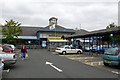
Morrisons Supermarket, Morpeth
Close to the centre of town on the main road out to the north east
Image: © Nigel Mykura
Taken: 25 Aug 2008
0.06 miles
8
A197 to Ashington
Roundabout to the northeast of Morpeth town centre.
Image: © Barbara Carr
Taken: 27 Mar 2013
0.06 miles
9
Morrisons Filling Station, Morpeth
The Morrison's fuel filling station in the centre of Morpeth. I'm unsure whether this was built at the same time as the new supermarket with which it shares the site, or if it was pre existing and built here so as to be close by to their previous location in the town.
Image: © Graham Robson
Taken: 21 May 2014
0.07 miles
10
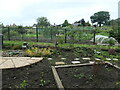
Tommy's Field allotments and community garden
The four acres of land, now known as Tommy's Field, have been used by the people of Morpeth since early times. The Freemen of Morpeth had the right of aftermath or pasturage on it from Michaelmas in September to Lady Day in March. The field retains Tommy's name ever since Tommy Longstaff ran a pub and a tannery on the site in the 19th century.
Image: © Christine Johnstone
Taken: 18 Jul 2023
0.07 miles