IMAGES TAKEN NEAR TO
Newgate Street, MORPETH, NE61 1BX
Introduction
This page details the photographs taken nearby to Newgate Street, NE61 1BX by members of the Geograph project.
The Geograph project started in 2005 with the aim of publishing, organising and preserving representative images for every square kilometre of Great Britain, Ireland and the Isle of Man.

There are currently over 7.5m images from over14,400 individuals and you can help contribute to the project by visiting https://www.geograph.org.uk
Image Map
Images are licensed for reuse under creativecommons.org/licenses/by-sa/2.0
Notes
- Clicking on the map will re-center to the selected point.
- The higher the marker number, the further away the image location is from the centre of the postcode.
Image Listing (175 Images Found)
Images are licensed for reuse under creativecommons.org/licenses/by-sa/2.0
Image
Details
Distance
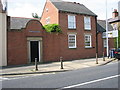
1
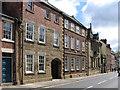
Morpeth - Newgate Street above Registry Office
Image: © Dave Bevis
Taken: 28 Apr 2012
0.01 miles
2
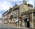
Morpeth - Registry Office
On Newgate Street. For an alternative view, please see Image
Image: © Dave Bevis
Taken: 28 Apr 2012
0.01 miles
3
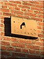
Newgate Street sundial
The dial is in good condition apart from having lost any numerals it may once have had. Age unknown. It was showing an accurate time, providing the mark to which it points is 11am. See also British Sundial Society entry SRN 1899.
Image: © Leanmeanmo
Taken: 24 Dec 2022
0.01 miles
4
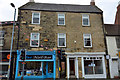
53 and 55, Newgate Street, Morpeth
53 and 55 Newgate Street, Morpeth currently occupied by Blue Nail Bar and Ryecroft Glenton.
Both are Grade II Listed, this is the listing text:
Description: 53 and 55, Newgate Street
Grade: II
Date Listed: 22 August 1986
English Heritage Building ID: 238754
OS Grid Reference: NZ1974286155
OS Grid Coordinates: 419742, 586155
Latitude/Longitude: 55.1693, -1.6916
Location: 51 Newgate Street, Morpeth, Northumberland NE61 1AT
Locality: Morpeth
County: Northumberland
Country: England
Postcode: NE61 1AT
MORPETH NEWGATE STREET (West side) Nos. 53 and 55
NZ 1986
22/265
GV II
2 houses, now offices. C18, remodelled early C19.
Dressed stone, brick to rear. Welsh slate roof. 3 storeys, 3 bays. Central round-arched entry to passage through to rear of building. Flanking early C20 shop fronts. 2-pane sashes with projecting sills. Gabled roof with flat coping and brick end stacks. 2-storey rear wing with 12-pane sashes.
Listing NGR: NZ1974286155
Image: © Steve Ellwood
Taken: 21 Sep 2016
0.02 miles
5
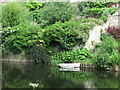
Rowing Boat On The River Wansbeck, Morpeth
This stretch of the River Wansbeck was named as 'Horse Hole' on the first Ordnance Survey Six-Inch map of the area published in 1866. However, by the time of the publication of the next edition of the map in 1898, this name had disappeared from the map.
Image: © Geoff Holland
Taken: 2 Jul 2020
0.03 miles
6
Morpeth - Newgate Street near junction with Copper Chare
Image: © Dave Bevis
Taken: 28 Apr 2012
0.05 miles
7
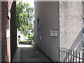
Dawson Place, Morpeth
Laneway leading to Nos.9 to 36 Dawson Place.
Image: © Willie Duffin
Taken: 22 Jul 2012
0.05 miles
8
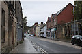
Newgate Street, Morpeth
The gateway to the Church of St James the Great is to the right - see Image by Peter Robinson.
Image: © Jim Barton
Taken: 1 Oct 2019
0.05 miles
9
Hampton Court House, Morpeth
Situated on the A192.
Image: © Willie Duffin
Taken: 22 Jul 2012
0.05 miles
10

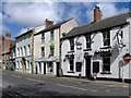
The Black & Grey, Morpeth
On Newgate Street.
Image: © JThomas
Taken: 17 Apr 2015
0.05 miles