IMAGES TAKEN NEAR TO
Comb Hill, HALTWHISTLE, NE49 9EW
Introduction
This page details the photographs taken nearby to Comb Hill, NE49 9EW by members of the Geograph project.
The Geograph project started in 2005 with the aim of publishing, organising and preserving representative images for every square kilometre of Great Britain, Ireland and the Isle of Man.

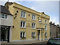
There are currently over 7.5m images from over14,400 individuals and you can help contribute to the project by visiting https://www.geograph.org.uk
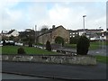
Image Map
Images are licensed for reuse under creativecommons.org/licenses/by-sa/2.0
Notes
- Clicking on the map will re-center to the selected point.
- The higher the marker number, the further away the image location is from the centre of the postcode.
Image Listing (149 Images Found)
Images are licensed for reuse under creativecommons.org/licenses/by-sa/2.0
Image
Details
Distance
1
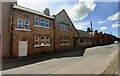
"Another former school, the very first one in Haltwhistle"
"In 1719 Lady Dorothy Capel gave an endowment of £37.10 a year to set up this school." Text from the Walk 06 [Bastles and Burn, Railways and Reivers] leaflet in The Haltwhistle Rings series.
Image: © Christine Johnstone
Taken: 17 Feb 2020
0.03 miles
2
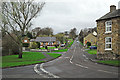
Combe Hill Road
Climbs out of town in a north westerly direction, eventually meeting the B6318 Military Road.
Image: © Rose and Trev Clough
Taken: 8 Nov 2014
0.04 miles
3
Boarded up shop on Fair Hill
The premises of I. Bell & Son have been closed for several years.
Image: © Rose and Trev Clough
Taken: 8 Nov 2014
0.08 miles
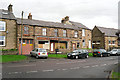
4
I Bell & Sons, Fair Hill, Haltwhistle
Former greengrocer's shop Image
Image: © Andrew Curtis
Taken: 25 Sep 2015
0.08 miles
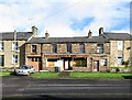
5
Centre of Britain Hotel
Haltwhistle’s most historic building, the oldest part was a Border Reivers' Pele Tower, dating from the 15th Century. Later it became a Manor House, Excise Office, Coaching Inn, Post Office, Temperance Hotel, Pub and Cafe. In 1997 the building was completely refurbished, finding many archaeological and architectural features - many of which have been included in the presentation of the reborn Hotel.
Image: © Ken Brown
Taken: 23 May 2005
0.08 miles
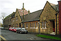
6
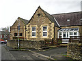
School converted to housing
View from Willia Road, the site extends round the corner to Fair Hill.
Image: © Rose and Trev Clough
Taken: 8 Nov 2014
0.10 miles
8
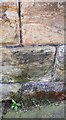
Benchmark on Masonic Hall on south side of Greenholme Road
Ordnance Survey cut mark benchmark levelled at 124.291m above Newlyn Datum verified 1954
Image: © Roger Templeman
Taken: 25 May 2023
0.13 miles
9
Masonic Hall and Bank's Terrace houses on south side of Greenholme Road
There is an Ordnance Survey benchmark Image on the front of the hall
Image: © Roger Templeman
Taken: 25 May 2023
0.13 miles
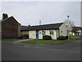
10
Haltwhistle Masonic Hall
Located in Banks Terrace, Greenholme Road.
Five groups of Freemasons meet at the hall. It is also used for community activities, and can be hired for events (see website http://haltwhistlefreemasons.org.uk/ ).
The Masons purchased the building in 1964. It was originally a drill hall, HQ of F Company, 4th Battalion, Northumberland Fusiliers, opened 1913.
Image: © Rose and Trev Clough
Taken: 8 Nov 2014
0.13 miles