IMAGES TAKEN NEAR TO
Heatherlands, HALTWHISTLE, NE49 9EJ
Introduction
This page details the photographs taken nearby to Heatherlands, NE49 9EJ by members of the Geograph project.
The Geograph project started in 2005 with the aim of publishing, organising and preserving representative images for every square kilometre of Great Britain, Ireland and the Isle of Man.

There are currently over 7.5m images from over14,400 individuals and you can help contribute to the project by visiting https://www.geograph.org.uk
Image Map
Images are licensed for reuse under creativecommons.org/licenses/by-sa/2.0
Notes
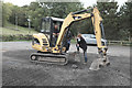
- Clicking on the map will re-center to the selected point.
- The higher the marker number, the further away the image location is from the centre of the postcode.
Image Listing (285 Images Found)
Images are licensed for reuse under creativecommons.org/licenses/by-sa/2.0
Image
Details
Distance
1
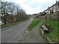
Raised pavement, Fair Hill, Haltwhistle
Looking west. The houses above the pavement were built after the 1940s.
Image: © Christine Johnstone
Taken: 17 Feb 2020
0.04 miles
3
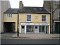
Centre of Britain Laundrette and Gallery
For further information on the controversy over what the "centre of Britain" really means and where it is, see http://news.bbc.co.uk/2/hi/uk/2271914.stm
The protagonist of Haltwhistle's claim to the title, David Taylor, owns this Laundrette and Gallery, as well as the "Centre of Britain Hotel" Image just along the street.
Image: © Oliver Dixon
Taken: 14 Apr 2008
0.07 miles
4
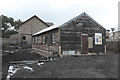
Football club house
This former scout hut, locally believed to date abck to the first world war, and allgedly once part of a prisoner of war camp, has been relocated here and is being rebuilt as a clubhouse for the local football team
Image: © Bob Harvey
Taken: 23 Sep 2017
0.07 miles
5
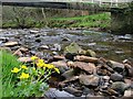
Haltwhistle Burn
The flowers, I believe are Marsh Marigolds, a name which seems out of place on the banks of this fast flowing stream.
Image: © Mick Garratt
Taken: 30 Apr 2006
0.08 miles
6
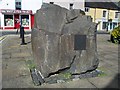
Millennium stone and plaque
On a large whinstone in the market place.
Image: © David Clark
Taken: 20 Sep 2010
0.08 miles
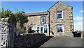
7
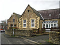
School converted to housing
View from Willia Road, the site extends round the corner to Fair Hill.
Image: © Rose and Trev Clough
Taken: 8 Nov 2014
0.08 miles
8
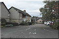
Inside the housing estate
A short cul-de-sac within Image
Image: © Bob Harvey
Taken: 23 Sep 2017
0.08 miles
9
Construction team
Local volunteers working on the landscaping around Image
Image: © Bob Harvey
Taken: 23 Sep 2017
0.08 miles
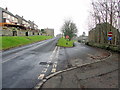
10
#25 Fair Hill on north side of road
The house is on the site of a demolished school on which there was an Ordnance Survey benchmark levelled at 132.804m above Newlyn Datum verified 1954. Only a date stone in the southern boundary wall of school remains Image
Image: © Roger Templeman
Taken: 25 May 2023
0.08 miles