IMAGES TAKEN NEAR TO
Lantys Lonnen, HALTWHISTLE, NE49 0DB
Introduction
This page details the photographs taken nearby to Lantys Lonnen, NE49 0DB by members of the Geograph project.
The Geograph project started in 2005 with the aim of publishing, organising and preserving representative images for every square kilometre of Great Britain, Ireland and the Isle of Man.

There are currently over 7.5m images from over14,400 individuals and you can help contribute to the project by visiting https://www.geograph.org.uk
Image Map
Images are licensed for reuse under creativecommons.org/licenses/by-sa/2.0
Notes
- Clicking on the map will re-center to the selected point.
- The higher the marker number, the further away the image location is from the centre of the postcode.
Image Listing (343 Images Found)
Images are licensed for reuse under creativecommons.org/licenses/by-sa/2.0
Image
Details
Distance
1
The lane from Murray's Yard with the Church of the Holy Cross
The narrow lane curves down from Murray's Yard; photo taken from the junction with Lanty's Lonnen
Image: © Andy Parrett
Taken: 12 Aug 2009
0.02 miles
3
Ashcroft Guest House B&B, Lanty's Lonnen
Image: © Mike Quinn
Taken: 28 Mar 2012
0.03 miles
4
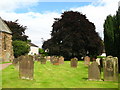
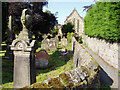
The Church of the Holy Cross, Haltwhistle - graveyard
See Image
Image: © Mike Quinn
Taken: 16 Aug 2010
0.03 miles
5
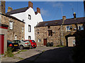
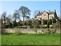
Murray's Yard, Haltwhistle, Northumberland
There used to be a mineral water factory in this yard. Also seen in the photo is the rear of the Manor House Inn, a former fortified house or 'bastle'
Image: © Andy Parrett
Taken: 12 Aug 2009
0.03 miles
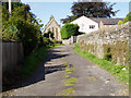
7
Churchyard and path at rear of the Church of the Holy Cross, Haltwhistle
The path leads off the lane below Murray's Yard
Image: © Andy Parrett
Taken: 12 Aug 2009
0.04 miles
8
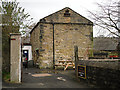
Outbuilding with dovecote
An old stone building behind the Manor House Inn.
Image: © Rose and Trev Clough
Taken: 8 Nov 2014
0.04 miles
9
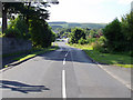
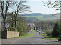
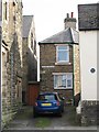
Lanty's Lonnen, Haltwhistle, Northumberland
A view along this unusually named road, which leads southwards down from Main Street.
Image: © Andy Parrett
Taken: 12 Aug 2009
0.04 miles
10
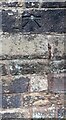
Benchmark on Holy Cross Church
Ordnance Survey 1GL bolt benchmark levelled at 121.923m above Newlyn Datum verified 1954. Previously levelled at 399.984 feet above Liverpool Datum in 1844 during the Carlisle to North Shields 1GL Survey. The surveyor's description was 'No. 78. Bolt in North-east corner of Haltwhistle Parish Church ; 2.80 ft. above surface'
Image: © Roger Templeman
Taken: 14 Apr 2023
0.04 miles