IMAGES TAKEN NEAR TO
Sparty Lea, HEXHAM, NE47 9UL
Introduction
This page details the photographs taken nearby to NE47 9UL by members of the Geograph project.
The Geograph project started in 2005 with the aim of publishing, organising and preserving representative images for every square kilometre of Great Britain, Ireland and the Isle of Man.

There are currently over 7.5m images from over14,400 individuals and you can help contribute to the project by visiting https://www.geograph.org.uk
Image Map
Images are licensed for reuse under creativecommons.org/licenses/by-sa/2.0
Notes
- Clicking on the map will re-center to the selected point.
- The higher the marker number, the further away the image location is from the centre of the postcode.
Image Listing (78 Images Found)
Images are licensed for reuse under creativecommons.org/licenses/by-sa/2.0
Image
Details
Distance
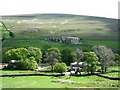
1
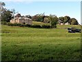
Low Huntwell
Low Huntwell Farmhouse is Grade II Listed (List Entry Number: 1042960): https://historicengland.org.uk/listing/the-list/list-entry/1042960
Huntwell was built for Thomas Sopwith between c.1860 and c.1870. Sopwith was mining agent for W.B. Lead Mines from 1841 to his retirement in 1871.
Coating Hill can be seen in the top right corner.
Image: © Andrew Curtis
Taken: 6 Oct 2020
0.00 miles
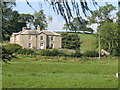
3
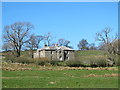
Low Huntwell (3)
A similar view in September (2008) is shown in Image
Image: © Mike Quinn
Taken: 18 Apr 2014
0.01 miles
4
Low Huntwell
The cottages at Fell View in Image are above the farm buildings across the valley of the East Allen, with Green Hill in Image on the horizon.
Image: © Mike Quinn
Taken: 26 May 2007
0.01 miles
6
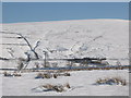
Snowy East Allen Dale near Low Huntwell
Looking east across the valley towards Image on the B6295.
Image: © Mike Quinn
Taken: 2 Mar 2010
0.03 miles
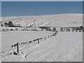
7
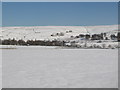
Snowy pastures near Low Huntwell
Looking across East Allen Dale towards Image
Image: © Mike Quinn
Taken: 2 Mar 2010
0.04 miles
8
Frozen moles on a wire
Looking across East Allen Dale towards Image on the B6295.
Image: © Mike Quinn
Taken: 2 Mar 2010
0.06 miles
9

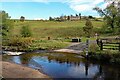
Footbridge downstream of ford
The ford is shown here Image
Image: © Andrew Curtis
Taken: 13 Oct 2020
0.08 miles