IMAGES TAKEN NEAR TO
Sinderhope, HEXHAM, NE47 9SE
Introduction
This page details the photographs taken nearby to NE47 9SE by members of the Geograph project.
The Geograph project started in 2005 with the aim of publishing, organising and preserving representative images for every square kilometre of Great Britain, Ireland and the Isle of Man.

There are currently over 7.5m images from over14,400 individuals and you can help contribute to the project by visiting https://www.geograph.org.uk
Image Map
Images are licensed for reuse under creativecommons.org/licenses/by-sa/2.0
Notes
- Clicking on the map will re-center to the selected point.
- The higher the marker number, the further away the image location is from the centre of the postcode.
Image Listing (169 Images Found)
Images are licensed for reuse under creativecommons.org/licenses/by-sa/2.0
Image
Details
Distance
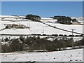
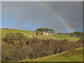
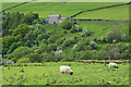
2
Pastures near West Garret's Hill
Photo taken from the minor road just north of Image (photo by Oliver Dixon).
Image: © Mike Quinn
Taken: 25 Mar 2009
0.01 miles
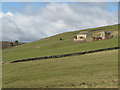
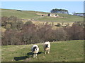
3
Farm near Sinderhope
West Garret's Hill Farm.
Image: © Helen Wilkinson
Taken: 20 Mar 2009
0.02 miles
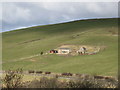
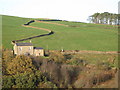
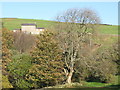
5
East Allen Dale below West Garret's Hill
Photo taken from the minor road to Image (photo by Les Hull); see also Image (photo by Helen Wilkinson).
Image: © Mike Quinn
Taken: 19 Mar 2009
0.02 miles
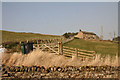
7
Sinderhope
Looking down to the bridge over the East Allen and the lane continuing to Huntrods.
Image: © Andrew Smith
Taken: 21 Dec 2006
0.10 miles
8
Across valley of Sinderhope Burn
Sinderhope Burn is a feeder stream to the River East Allen which lies out of view to the left in the image.
Image: © Trevor Littlewood
Taken: 6 Jun 2014
0.10 miles
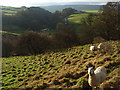
9
The valley of Sinderhope Burn
With the Image (photo by Bill Cresswell) on the far side of the valley (left).
Image: © Mike Quinn
Taken: 31 Oct 2009
0.10 miles