IMAGES TAKEN NEAR TO
Shilburn Road, HEXHAM, NE47 9LG
Introduction
This page details the photographs taken nearby to Shilburn Road, NE47 9LG by members of the Geograph project.
The Geograph project started in 2005 with the aim of publishing, organising and preserving representative images for every square kilometre of Great Britain, Ireland and the Isle of Man.

There are currently over 7.5m images from over14,400 individuals and you can help contribute to the project by visiting https://www.geograph.org.uk
Image Map
Images are licensed for reuse under creativecommons.org/licenses/by-sa/2.0
Notes
- Clicking on the map will re-center to the selected point.
- The higher the marker number, the further away the image location is from the centre of the postcode.
Image Listing (385 Images Found)
Images are licensed for reuse under creativecommons.org/licenses/by-sa/2.0
Image
Details
Distance
1
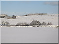
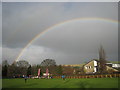
Snowy pastures near Lonkley Head (3)
Looking east of north across the valleys of Shield Burn and Philip Burn towards High Hope on the southern edge of Image
Image: © Mike Quinn
Taken: 6 Jan 2010
0.05 miles
2
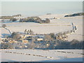
Panorama of snowy East Allen Dale (3 - The Dene and High Hope)
Image: © Mike Quinn
Taken: 8 Jan 2010
0.06 miles
3
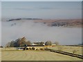
Morning mist in the valley of the Philip Burn below Lonkley
Image: © Mike Quinn
Taken: 21 Jan 2011
0.06 miles
5
Finishing the Hexhamshire Hobble Fell Race 2009
The finish of the Hexhamshire Hobble Race in Allendale. The building beyond the field is the Allendale Middle School.
Image: © Vicki Deritis
Taken: 6 Dec 2009
0.08 miles
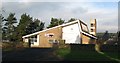
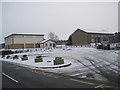
6
Fire station in Allendale Town
The fire station is in a quiet corner of the village on the north side of Shilburn Road.
Image: © Trevor Littlewood
Taken: 3 Feb 2017
0.08 miles
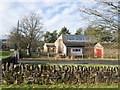
8
Ranters and Readers Allendale Library
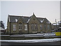
Isaac Holden raised the funds to help build this chapel for the Primitive Methodists around 1835. By this date the Primitive Methodists movement had split from the Wesleyans and followers were widely known as Ranters and later as Prims. In the twentieth century, when the chapel closed it has since continued in public use as the public library in Allendale retaining an upstairs gallery and original Victorian marble wall plaques. It is probably a rare example of a former chapel used in this way. The future of the library is now uncertain with a volunteer run library service being one option under consideration. Whether as a chapel or library, there is no better place to study the local history and geography of the Isaac's Tea Trail heritage walk.
Image: © Roger Morris
Taken: 22 May 2010
0.09 miles
10
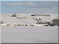
Snowy pastures near Lonkley Head (2)
Looking across the valleys of Shield Burn and Philip Burn towards Image
Image: © Mike Quinn
Taken: 6 Jan 2010
0.10 miles