IMAGES TAKEN NEAR TO
Allenheads, HEXHAM, NE47 9JF
Introduction
This page details the photographs taken nearby to NE47 9JF by members of the Geograph project.
The Geograph project started in 2005 with the aim of publishing, organising and preserving representative images for every square kilometre of Great Britain, Ireland and the Isle of Man.

There are currently over 7.5m images from over14,400 individuals and you can help contribute to the project by visiting https://www.geograph.org.uk
Image Map
Images are licensed for reuse under creativecommons.org/licenses/by-sa/2.0
Notes
- Clicking on the map will re-center to the selected point.
- The higher the marker number, the further away the image location is from the centre of the postcode.
Image Listing (99 Images Found)
Images are licensed for reuse under creativecommons.org/licenses/by-sa/2.0
Image
Details
Distance
3
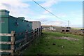
West End farm
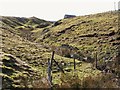
The large-scale map shows a disused lead mine in this area and the installation on the left might be something to do with that or perhaps just water resources. There is another photo here Image
Image: © Andrew Curtis
Taken: 6 Oct 2020
0.07 miles
6
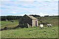
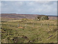
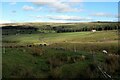
Barn near West End
Close to the former location of a small farm, Middle Rigg. The extant farm, West End, was formerly called High Middle Rigg.
Image: © Andrew Curtis
Taken: 6 Oct 2020
0.08 miles