IMAGES TAKEN NEAR TO
Ropehaugh, HEXHAM, NE47 9HG
Introduction
This page details the photographs taken nearby to NE47 9HG by members of the Geograph project.
The Geograph project started in 2005 with the aim of publishing, organising and preserving representative images for every square kilometre of Great Britain, Ireland and the Isle of Man.

There are currently over 7.5m images from over14,400 individuals and you can help contribute to the project by visiting https://www.geograph.org.uk
Image Map
Images are licensed for reuse under creativecommons.org/licenses/by-sa/2.0
Notes
- Clicking on the map will re-center to the selected point.
- The higher the marker number, the further away the image location is from the centre of the postcode.
Image Listing (90 Images Found)
Images are licensed for reuse under creativecommons.org/licenses/by-sa/2.0
Image
Details
Distance
2
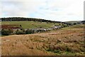
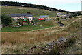
Dirt Pot (5)
Photo taken from the Carriers' Way in Image
Image: © Mike Quinn
Taken: 9 Jan 2009
0.03 miles
4
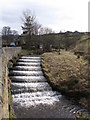
Steps in the bed of the River East Allen near Dirt Pot
Image: © Mike Quinn
Taken: 9 Mar 2008
0.04 miles
5
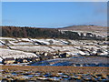
Dirt Pot (6)
Photo taken from the Carriers' Way in Image looking across East Allen Dale past the southern end of Woodhead Plantation towards the Image
Image: © Mike Quinn
Taken: 9 Jan 2009
0.04 miles
6
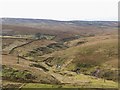
East Allen Dale near Dirt Pot
Image: © Mike Quinn
Taken: 11 Mar 2008
0.04 miles
7
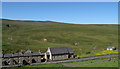
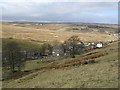
Primitive Methodist Church (converted) at Dirt Pot
Dirt Pot is a curiously named hamlet separated from Allenheads by just a short stretch of road. Seen here are several houses of Dirt Pot, which now includes the church as it's been converted to residential use.
Image: © Trevor Littlewood
Taken: 24 Jun 2009
0.05 miles
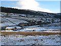
8
River East Allen at Dirt Pot
In the foreground is part of the aqueduct for Allenheads Lead Smelt Mill Image
Image: © Andrew Curtis
Taken: 23 Sep 2022
0.07 miles