IMAGES TAKEN NEAR TO
Allendale, HEXHAM, NE47 9DH
Introduction
This page details the photographs taken nearby to NE47 9DH by members of the Geograph project.
The Geograph project started in 2005 with the aim of publishing, organising and preserving representative images for every square kilometre of Great Britain, Ireland and the Isle of Man.

There are currently over 7.5m images from over14,400 individuals and you can help contribute to the project by visiting https://www.geograph.org.uk
Image Map
Images are licensed for reuse under creativecommons.org/licenses/by-sa/2.0
Notes
- Clicking on the map will re-center to the selected point.
- The higher the marker number, the further away the image location is from the centre of the postcode.
Image Listing (22 Images Found)
Images are licensed for reuse under creativecommons.org/licenses/by-sa/2.0
Image
Details
Distance
1
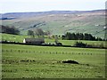
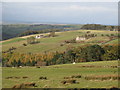
Allendale Golf Club
The club house and part of the golf course with Black Hill on Acton Moor on the far side of the river valley Image and Image
Image: © Mike Quinn
Taken: 4 Apr 2007
0.02 miles
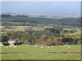
3
East Allen Dale
Looking over Allendale Golf Course across the valley towards the two lead flue smelting chimneys in Image
Image: © Mike Quinn
Taken: 6 Feb 2008
0.06 miles
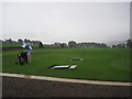
4
Allendale Golf Course
View of Allendale Golf Course and the Club House.
Image: © Peter McDermott
Taken: 29 Apr 2011
0.08 miles
5
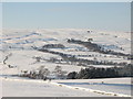
Snowy East Allen Dale north of High Studdon
Looking across the valley towards the Image
Image: © Mike Quinn
Taken: 3 Jan 2010
0.14 miles
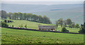
7
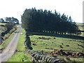
Back road to Sinderhope
Photo shows a section of the "back" road from Allendale Town to Sinderhope. The lane to the right in front of the copse leads down to the clubhouse of Allendale Golf Club.
Image: © Mike Quinn
Taken: 4 Apr 2007
0.18 miles
8
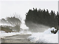
The answer, my friend ...
Photo shows the "high" road between Allendale Town and Sinderhope, around the "T" junction with the road that leads down past the golf clubhouse to the B6295. A similar view in April (2007) is shown in Image
Image: © Mike Quinn
Taken: 19 Jan 2018
0.18 miles
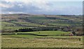
9
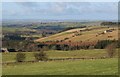
Pastures above Studdon Park (2)
Looking across the cleugh of Parkgates Burn towards South Scotch Hall (right) and Nether Scotch Hall (left).
Image: © Mike Quinn
Taken: 26 Oct 2008
0.19 miles
10
East Allen Dale (2)
Studdon Park is on the left, with Low Scotch Hall and Nether Scotch Hall on the far side of the valley of Parkgates Burn in Image
Image: © Mike Quinn
Taken: 6 Feb 2008
0.21 miles