IMAGES TAKEN NEAR TO
Whitfield, HEXHAM, NE47 8HQ
Introduction
This page details the photographs taken nearby to NE47 8HQ by members of the Geograph project.
The Geograph project started in 2005 with the aim of publishing, organising and preserving representative images for every square kilometre of Great Britain, Ireland and the Isle of Man.

There are currently over 7.5m images from over14,400 individuals and you can help contribute to the project by visiting https://www.geograph.org.uk
Image Map
Images are licensed for reuse under creativecommons.org/licenses/by-sa/2.0
Notes
- Clicking on the map will re-center to the selected point.
- The higher the marker number, the further away the image location is from the centre of the postcode.
Image Listing (20 Images Found)
Images are licensed for reuse under creativecommons.org/licenses/by-sa/2.0
Image
Details
Distance
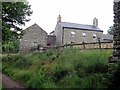
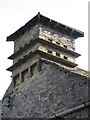
1
Monk from the north-east
Whitfield Hall can be seen to the right Image
Image: © Andrew Curtis
Taken: 23 Jun 2017
0.01 miles
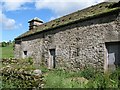
4
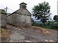
Dovecote at Monk Farm
See another view here Image
Image: © Andrew Curtis
Taken: 23 Jun 2017
0.01 miles
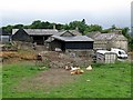
7
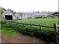
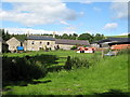
Monk Farm
The land hereabouts formerly belonged to Hexham Abbey which is presumably the source of the name of the farm.
Image: © Oliver Dixon
Taken: 2 Jun 2010
0.02 miles
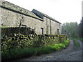
9
Monk Farm (2)
Taken from the south on the track to Monk Cottage.
Image: © Mike Quinn
Taken: 29 Jun 2007
0.04 miles
10
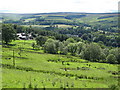
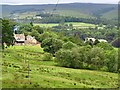
Pastures above Monk Farm
Whitfield Hall in Image is in the middle distance (right) with the upper West Allen valley behind.
Image: © Mike Quinn
Taken: 29 Jun 2007
0.04 miles