IMAGES TAKEN NEAR TO
Bardon Mill, HEXHAM, NE47 7JP
Introduction
This page details the photographs taken nearby to NE47 7JP by members of the Geograph project.
The Geograph project started in 2005 with the aim of publishing, organising and preserving representative images for every square kilometre of Great Britain, Ireland and the Isle of Man.

There are currently over 7.5m images from over14,400 individuals and you can help contribute to the project by visiting https://www.geograph.org.uk
Image Map
Images are licensed for reuse under creativecommons.org/licenses/by-sa/2.0
Notes
- Clicking on the map will re-center to the selected point.
- The higher the marker number, the further away the image location is from the centre of the postcode.
Image Listing (126 Images Found)
Images are licensed for reuse under creativecommons.org/licenses/by-sa/2.0
Image
Details
Distance
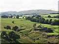
1
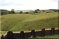
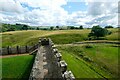
High Fogrigg, Vindolanda
The view towards the farm from the reconstruction of the roman fortifications.
Image: © Bob Embleton
Taken: 8 Aug 2011
0.00 miles
2
Towards Fogtigg
From Crossing of minor roads by limekiln below Roman Signal Station with Fogtigg centre, Long Stone far left and Vindolanda far right.
Image: © Barry Boxer
Taken: 21 Mar 2010
0.01 miles
3
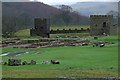
Vindolanda Fort
At Vindolanda there is a reconstruction of a stone built turret and also a "Turf Wall" timber milecastle.
Image: © Bill Cresswell
Taken: 31 Jan 2007
0.06 miles
4

"Spaceship" over Vindolanda
Having taken http://www.geograph.org.uk/photo/1780226, turning to the south this cloud formation reminded me of Captain James T Kirk's Enterprize spaceship in the Star Trek series. Showing my age perhaps?
Image: © Barry Boxer
Taken: 24 Mar 2010
0.09 miles
6
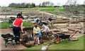
Archaeologists at Work in Vindolanda
The archaeologists are excavating an area within the confines of the 3rd century fort. Behind are the remains of the civilian settlement.
Image: © Mick Garratt
Taken: 30 Apr 2006
0.09 miles
7
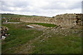
Roman fort wall, Vindolanda
This section of the wall of the third stone fort was excavated during 2005 and is being consolidated for permanent display; the remains of two earlier fort walls were also excavated. the photo was taken from near the south west corner of the fort, looking to the west wall.
Image: © Phil Champion
Taken: 8 Apr 2007
0.09 miles
8
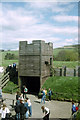
Hadrian's Wall Replica at Vindolanda
The replica sections of Hadrian's Wall at Vindolanda include a stone section of wall with a turret, and a length of turf wall with a timber milecastle gateway. Both were constructed in the summer of 1974 as a part of a research project to study how long, and what materials it would take, to build such structures. They also provide a scale of how tall Hadrian's Wall may have been.
Info source: Vindolanda Charitable Trust
Wikipedia Vindolanda https://en.wikipedia.org/wiki/Vindolanda
Image: © Jeff Buck
Taken: 11 Jul 2023
0.10 miles
9
Reconstruction of tower and turf wall, Vindolanda
This reconstruction of part of Hadrian's Wall was built at Vindolanda in 1973. There is also a reconstructed section of stone wall, just out of shot. The actual roman wall is about a mile to the north.
Image shows the view from the other side of the wall, taken 18 years later, and rather worse for wear.
Image: © Phil Champion
Taken: Unknown
0.11 miles
10
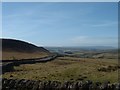
The cleugh of Doe Sike below Vindolanda
Looking towards Winshield Crags.
Image: © Mike Quinn
Taken: 30 Jul 2009
0.11 miles