IMAGES TAKEN NEAR TO
Bardon Mill, HEXHAM, NE47 7BY
Introduction
This page details the photographs taken nearby to NE47 7BY by members of the Geograph project.
The Geograph project started in 2005 with the aim of publishing, organising and preserving representative images for every square kilometre of Great Britain, Ireland and the Isle of Man.

There are currently over 7.5m images from over14,400 individuals and you can help contribute to the project by visiting https://www.geograph.org.uk
Image Map
Images are licensed for reuse under creativecommons.org/licenses/by-sa/2.0
Notes
- Clicking on the map will re-center to the selected point.
- The higher the marker number, the further away the image location is from the centre of the postcode.
Image Listing (8 Images Found)
Images are licensed for reuse under creativecommons.org/licenses/by-sa/2.0
Image
Details
Distance
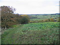
3
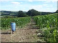
Public footpath through a field of maize
Just below Shaws Farm. At least ramblers don't have to hack their way through the crop. Pheasant feeder in the foreground.
Image: © Oliver Dixon
Taken: 31 Aug 2020
0.08 miles
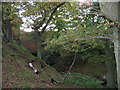
4
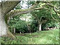
Valley below Shaws Farm
A tiny stream cuts a deep cleft into the hillside below Shaws Farm. The map depicts waterfalls, but for most of the time the trickle of water would not make for an impressive sight. A couple of home-made swings hanging above the gorge offer some childish excitement.
Image: © Oliver Dixon
Taken: 31 Aug 2020
0.15 miles
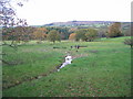
5
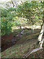
Stream below Shaws Farm
The Pathfinder map indicates waterfalls along this valley, but there was so little water in the stream that the "falls" were virtually dry at the time of my visit.
Image: © Oliver Dixon
Taken: 26 Oct 2011
0.16 miles