IMAGES TAKEN NEAR TO
California Gardens, HEXHAM, NE47 6JW
Introduction
This page details the photographs taken nearby to California Gardens, NE47 6JW by members of the Geograph project.
The Geograph project started in 2005 with the aim of publishing, organising and preserving representative images for every square kilometre of Great Britain, Ireland and the Isle of Man.

There are currently over 7.5m images from over14,400 individuals and you can help contribute to the project by visiting https://www.geograph.org.uk
Image Map
Images are licensed for reuse under creativecommons.org/licenses/by-sa/2.0
Notes
- Clicking on the map will re-center to the selected point.
- The higher the marker number, the further away the image location is from the centre of the postcode.
Image Listing (115 Images Found)
Images are licensed for reuse under creativecommons.org/licenses/by-sa/2.0
Image
Details
Distance
1

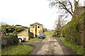
Station Road, Haydon Bridge
Station Road in Haydon Bridge runs alongside the Tyne Valley rail line in Haydon Bridge.
Image: © Graham Robson
Taken: 14 Oct 2023
0.04 miles
2
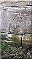
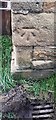
Benchmark on roadside wall right of subway entrance on SE side of Station Road
Ordnance Survey cut mark benchmark levelled at 62.258m above Newlyn Datum verified in 1954
Image: © Roger Templeman
Taken: 26 Feb 2022
0.04 miles
3
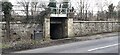
Subway under railway line on SE side of Station Road (B6319)
There is an Ordnance Survey benchmark Image on the wall pier on the right hand side of the subway entrance tunnel which takes a footpath under the Carlisle to Newcastle railway to the side of the South Tyne
Image: © Roger Templeman
Taken: 26 Feb 2022
0.04 miles
4
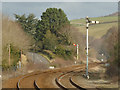
Semaphore signals east of Haydon Bridge station
The Carlisle to Newcastle line is one of the few through routes still signalled by this 19th century method. The signal to the left is the 'starter' for the eastbound platform, in the raised or 'off' position indicating 'line clear'. Unusually it is situated some 400 metres beyond the station rather than at the end of the platform. To the right is the 'home' signal for the westbound platform, in this view in the down or 'on' position indicating 'line blocked' - in this instance by the level crossing gates.
Image: © Stephen Craven
Taken: 14 Mar 2020
0.07 miles
5
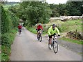
The road up Cruel Sike
From the B6319 at the bottom, this minor road climbs steeply upwards towards Haydon alongside the aptly-named Cruel Sike. The cyclists are participating in the H100, a formidable test of man and machine, which over the course of 100 kilometres seeks out every steep hill (up or down) on either side of the South Tyne.
Image: © Oliver Dixon
Taken: 26 Sep 2010
0.08 miles
7
Benchmark on farm building on west side of road at West Mill Hills
Ordnance Survey cut mark benchmark levelled at 72.616m above Newlyn Datum verified 1954
Image: © Roger Templeman
Taken: 26 Feb 2022
0.10 miles
8

Dry ford over the Langley Burn
Just above the confluence with the River South Tyne. The ford gives access to the playing fields of Haydon Bridge United AFC.
Image: © Oliver Dixon
Taken: 2 Jan 2019
0.11 miles
9
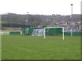
Playing field of Haydon Bridge United AFC
On the flood plain of the River South Tyne.
Image: © Oliver Dixon
Taken: 2 Jan 2019
0.11 miles
10
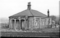
Haydon Bridge: the original station house of June 1836, 1956
View southward, just east of the present station. This was the terminus from Newcastle, between June 1836 and June 1838, of the Newcastle & Carlisle Railway, which was built in stages, opened throughout on 18/6/38 and not amalgamated with the North Eastern Railway until July 1862.
Image: © Walter Dendy, deceased
Taken: 16 Apr 1956
0.11 miles