IMAGES TAKEN NEAR TO
Langley-on-Tyne, HEXHAM, NE47 5NE
Introduction
This page details the photographs taken nearby to NE47 5NE by members of the Geograph project.
The Geograph project started in 2005 with the aim of publishing, organising and preserving representative images for every square kilometre of Great Britain, Ireland and the Isle of Man.

There are currently over 7.5m images from over14,400 individuals and you can help contribute to the project by visiting https://www.geograph.org.uk
Image Map
Images are licensed for reuse under creativecommons.org/licenses/by-sa/2.0
Notes
- Clicking on the map will re-center to the selected point.
- The higher the marker number, the further away the image location is from the centre of the postcode.
Image Listing (6 Images Found)
Images are licensed for reuse under creativecommons.org/licenses/by-sa/2.0
Image
Details
Distance
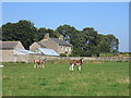
2
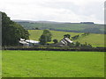
Sillywrea Farm
And West Sillywrea to the left. Farm high above Tynedale.
Image: © Oliver Dixon
Taken: 27 Mar 2012
0.05 miles
4
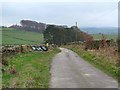
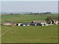
Farm road to Sillywrea Farm
Sillywrea Farm lies behind the nearest shelter belt of trees
Image: © Oliver Dixon
Taken: 18 Nov 2011
0.15 miles