IMAGES TAKEN NEAR TO
Newbrough, HEXHAM, NE47 5AT
Introduction
This page details the photographs taken nearby to NE47 5AT by members of the Geograph project.
The Geograph project started in 2005 with the aim of publishing, organising and preserving representative images for every square kilometre of Great Britain, Ireland and the Isle of Man.

There are currently over 7.5m images from over14,400 individuals and you can help contribute to the project by visiting https://www.geograph.org.uk
Image Map
Images are licensed for reuse under creativecommons.org/licenses/by-sa/2.0
Notes
- Clicking on the map will re-center to the selected point.
- The higher the marker number, the further away the image location is from the centre of the postcode.
Image Listing (20 Images Found)
Images are licensed for reuse under creativecommons.org/licenses/by-sa/2.0
Image
Details
Distance
3

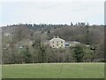
Newbrough Lodge
The term "Lodge" is used here to denote something on a much grander scale than the usual gatehouse. A Grade II listed building, dating from 1796 with more recent extensions. The low wall marks a haha.
Image: © Oliver Dixon
Taken: 26 Jun 2011
0.02 miles
4
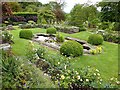
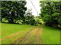
Parkland at Newbrough Lodge
Taken during a Red Cross Gardens Open Day.
Image: © Clive Nicholson
Taken: 1 Jul 2007
0.04 miles
6
Wooden House at the entrance to Newbrough Lodge
Image: © Les Hull
Taken: 4 Apr 2007
0.16 miles
8

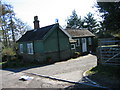
New England Cottage at the Entrance of Newbrough Lodge
A lick of paint can work wonders.
Image: © Les Hull
Taken: 9 Jan 2019
0.18 miles
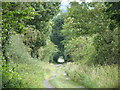
9
Track south of Greyside
The track is embanked over a shallow valley, a tributary of Newbrough Burn, and does lead north to Greyside Farm. Old maps show, however, that it was probably originally built to serve lead workings, south of the farm on the left bank of Newbrough Burn, and potentially another on the east bank. These are marked as 'Old Lead Workings' on the 1:2,500 OS map of 1922. Neither track, nor workings, are shown on the first edition map of 1861.
Image: © Andrew Curtis
Taken: 4 Jun 2020
0.18 miles
10
Track north of Newbrough East Lodge (3)
Image: © Mike Quinn
Taken: 16 Sep 2010
0.19 miles