IMAGES TAKEN NEAR TO
Steel, HEXHAM, NE47 0HA
Introduction
This page details the photographs taken nearby to NE47 0HA by members of the Geograph project.
The Geograph project started in 2005 with the aim of publishing, organising and preserving representative images for every square kilometre of Great Britain, Ireland and the Isle of Man.

There are currently over 7.5m images from over14,400 individuals and you can help contribute to the project by visiting https://www.geograph.org.uk
Image Map
Images are licensed for reuse under creativecommons.org/licenses/by-sa/2.0
Notes
- Clicking on the map will re-center to the selected point.
- The higher the marker number, the further away the image location is from the centre of the postcode.
Image Listing (28 Images Found)
Images are licensed for reuse under creativecommons.org/licenses/by-sa/2.0
Image
Details
Distance
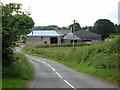
2
Road past High Staples from Whitley Chapel
Staples refers to the name of gate pillars I believe
Image: © P Glenwright
Taken: 9 Oct 2006
0.04 miles
3
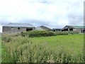
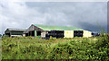
High Staples Farm
The conical roof second from left is that of a circular "gin gang" - a mill driven by horses walking round in a circle. A much better view of the ging gang can be seen in Image
Image: © Oliver Dixon
Taken: 6 Aug 2017
0.04 miles
5
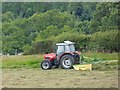
Bales beside barn at High Staples
Traditionally bound in black, bales of silage (perhaps haylage,) at the farm with yellow ones appearing too.
Image: © Trevor Littlewood
Taken: 18 Jul 2019
0.06 miles
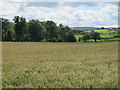
7
Turning the hay at High Staples Farm
The woods along Rowley Burn In the background.
Image: © Oliver Dixon
Taken: 6 Aug 2017
0.15 miles
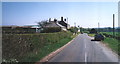
8
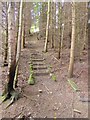
Steps through the wood
On the footpath from the Devil's Water up to High Staples Farm.
Image: © Oliver Dixon
Taken: 6 Aug 2017
0.15 miles
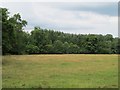
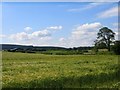
10
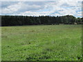
Farmland and woodland below High Staples
The buildings above green pastures (far right) are those at Image photographed by Oliver Dixon.
Image: © Mike Quinn
Taken: 9 Aug 2011
0.17 miles