IMAGES TAKEN NEAR TO
Giles Place, HEXHAM, NE46 3QE
Introduction
This page details the photographs taken nearby to Giles Place, NE46 3QE by members of the Geograph project.
The Geograph project started in 2005 with the aim of publishing, organising and preserving representative images for every square kilometre of Great Britain, Ireland and the Isle of Man.

There are currently over 7.5m images from over14,400 individuals and you can help contribute to the project by visiting https://www.geograph.org.uk
Image Map
Images are licensed for reuse under creativecommons.org/licenses/by-sa/2.0
Notes
- Clicking on the map will re-center to the selected point.
- The higher the marker number, the further away the image location is from the centre of the postcode.
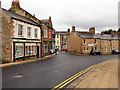
Image Listing (990 Images Found)
Images are licensed for reuse under creativecommons.org/licenses/by-sa/2.0
Image
Details
Distance
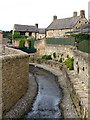
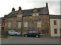
1
45 Gilesgate
The building has an 18th C front to an older house; it is Grade II listed https://historicengland.org.uk/listing/the-list/list-entry/1042587?section=official-list-entry .
The adjoining building is shown in Image
Image: © Mike Quinn
Taken: 1 Feb 2008
0.01 miles
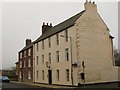
4
Holy Island House, Hexham
The building dates from the 17th century (above the door is carved "TKB 1657"). Apparently the name is nothing to do with Lindisfarne, but because the property sits between two streams. It is listed grade II* (list entry 1042573).
Image: © Stephen Craven
Taken: 14 Mar 2020
0.01 miles
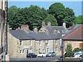
6
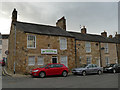
Saxon Financial Advice, Gilesgate, Hexham
What caught my eye was not so much the building or the business name, but the unusual style of water valve marker ("SV 15ft" painted on a wooden board on the side of the house). The valve cover is still visible in the middle of the road.
Image: © Stephen Craven
Taken: 14 Mar 2020
0.01 miles
7
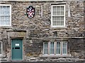
Hexham: Holy Island House - detail
This house once stood on a narrow strip of land between two burns, the nearer of which is now culverted - hence its name. It is Elizabethan in style, though dated 1657. The first-floor windows were once mullioned, like the ground-floor ones. Grander twelve-light windows were added in the 18th century. The ends of the huge transverse beams supporting the upper floors are very prominent.
Image: © John Sutton
Taken: 17 Feb 2012
0.01 miles
8
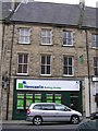
Newcastle Building Society, Hexham
A pity the modern sign doesn't complement the traditional appearance of the building.
Image: © Kenneth Allen
Taken: 14 Jun 2006
0.01 miles
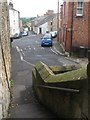
9
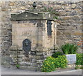
The Glovers' Pant
This water fountain, erected in 1858, was fed from a well on the Sele; it is Grade II listed https://historicengland.org.uk/listing/the-list/list-entry/1042572?section=official-list-entry .
Image: © Mike Quinn
Taken: 29 Aug 2007
0.02 miles