IMAGES TAKEN NEAR TO
Fenwick Grove, HEXHAM, NE46 3ED
Introduction
This page details the photographs taken nearby to Fenwick Grove, NE46 3ED by members of the Geograph project.
The Geograph project started in 2005 with the aim of publishing, organising and preserving representative images for every square kilometre of Great Britain, Ireland and the Isle of Man.

There are currently over 7.5m images from over14,400 individuals and you can help contribute to the project by visiting https://www.geograph.org.uk
Image Map
Images are licensed for reuse under creativecommons.org/licenses/by-sa/2.0
Notes
- Clicking on the map will re-center to the selected point.
- The higher the marker number, the further away the image location is from the centre of the postcode.
Image Listing (383 Images Found)
Images are licensed for reuse under creativecommons.org/licenses/by-sa/2.0
Image
Details
Distance
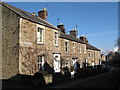
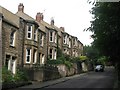
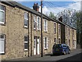
3
Hexham: terraced houses on Cockshaw
Brick on the left, stone on the right.
Image: © John Sutton
Taken: 12 Jul 2021
0.05 miles
4
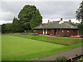
Bowling green pavilion, Hexham
In Hexham House grounds, a public park
Image: © Peter Robinson
Taken: 13 Sep 2009
0.05 miles
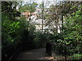
6
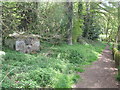
Footpath by the Cockshaw Burn
Shows the location of Image
Image: © Mike Quinn
Taken: 30 Apr 2010
0.06 miles
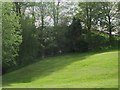
7
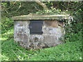
The Sele Well
This well was "A gathering place for local people and a very important source of drinking water for [the Cockshaw area of Hexham and was] in use until the 20th C." {Source: Hexham Local History Society leaflet "Essential Hexham".}
Image: © Mike Quinn
Taken: 30 Apr 2010
0.07 miles