IMAGES TAKEN NEAR TO
HEXHAM, NE46 2LQ
Introduction
This page details the photographs taken nearby to NE46 2LQ by members of the Geograph project.
The Geograph project started in 2005 with the aim of publishing, organising and preserving representative images for every square kilometre of Great Britain, Ireland and the Isle of Man.

There are currently over 7.5m images from over14,400 individuals and you can help contribute to the project by visiting https://www.geograph.org.uk
Image Map
Images are licensed for reuse under creativecommons.org/licenses/by-sa/2.0
Notes
- Clicking on the map will re-center to the selected point.
- The higher the marker number, the further away the image location is from the centre of the postcode.
Image Listing (15 Images Found)
Images are licensed for reuse under creativecommons.org/licenses/by-sa/2.0
Image
Details
Distance
1
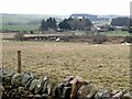
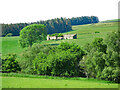
Pond below Walley Thorn Farm
Cooks House Farm beyond.
Image: © Oliver Dixon
Taken: 21 Dec 2021
0.12 miles
2
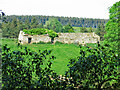
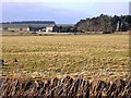
Farmland and woodland around Ardley Stobb
A long-abandoned farmhouse high above the Ham Burn, west of Low Ardley. There's been further deterioration since 2009 - see Image (photographed by Peter McDermott).
Image: © Mike Quinn
Taken: 12 Jun 2023
0.20 miles
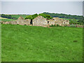

6
The valley of the Ham Burn around Ardley Stobb
See also Image
Image: © Mike Quinn
Taken: 12 Jun 2023
0.21 miles
7

Ardley Stobb (4)
Image: © Mike Quinn
Taken: 12 Jun 2023
0.21 miles

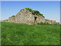
10
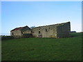
Ardley Stobb
Ruined farmhouse west of Low Ardley.
Image: © Les Hull
Taken: 4 Jan 2006
0.22 miles