IMAGES TAKEN NEAR TO
CORBRIDGE, NE45 5PZ
Introduction
This page details the photographs taken nearby to NE45 5PZ by members of the Geograph project.
The Geograph project started in 2005 with the aim of publishing, organising and preserving representative images for every square kilometre of Great Britain, Ireland and the Isle of Man.

There are currently over 7.5m images from over14,400 individuals and you can help contribute to the project by visiting https://www.geograph.org.uk
Image Map
Images are licensed for reuse under creativecommons.org/licenses/by-sa/2.0
Notes
- Clicking on the map will re-center to the selected point.
- The higher the marker number, the further away the image location is from the centre of the postcode.
Image Listing (24 Images Found)
Images are licensed for reuse under creativecommons.org/licenses/by-sa/2.0
Image
Details
Distance
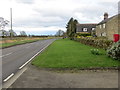
1
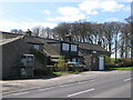
Cottages at Halton Shields
Shows the location of Image
Image: © Mike Quinn
Taken: 22 Apr 2009
0.01 miles
3
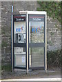
Bilingual Welsh/English telephone box at Halton Shields
My theory is that it should have been sent to Wrexham - not Hexham. I've also come across bilingual Welsh/English deposit slips in a Hexham bank, and bilingual Welsh/English plastic bags in a Hexham supermarket.
Image: © Mike Quinn
Taken: 22 Apr 2009
0.01 miles
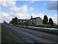
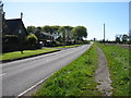
5
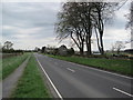
Road (B6318) at Halton Shields
Looking eastward.
Image: © Peter Wood
Taken: 30 Mar 2017
0.03 miles
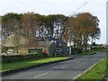
7
Halton Shields, on the B6318
At this point the Hadrian's Wall Path follows the footpath beside the road.
Image: © David Purchase
Taken: 25 May 2013
0.04 miles
8
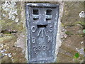
Ordnance Survey Flush Bracket 2395
This bracket can be found on the wall of a house - private dwelling - at Halton Shields. The benchmark height is recorded as being 197.069 metres above sea level.
For more detail see : http://www.bench-marks.org.uk/bm1603
Image: © Peter Wood
Taken: 30 Mar 2017
0.05 miles
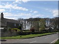
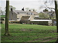
10
Halton Shields
Hamlet on the Military Road, B6318 built on the site of Roman Milecastle 20, one of the fortifications along the line of Hadrian's Wall
http://en.wikipedia.org/wiki/Hadrians_Wall. Hadrians Wall National Trail which runs 135 km from Bowness-on-Solway to Wallsend
http://www.nationaltrail.co.uk/hadrianswall/ follows the footway on the opposite side of the road at this point.
Image: © Oliver Dixon
Taken: 29 Oct 2008
0.07 miles