IMAGES TAKEN NEAR TO
CORBRIDGE, NE45 5NP
Introduction
This page details the photographs taken nearby to NE45 5NP by members of the Geograph project.
The Geograph project started in 2005 with the aim of publishing, organising and preserving representative images for every square kilometre of Great Britain, Ireland and the Isle of Man.

There are currently over 7.5m images from over14,400 individuals and you can help contribute to the project by visiting https://www.geograph.org.uk
Image Map (Loading...)


Getting Data...Please wait
Leaflet Map data © OpenStreetMap
Images are licensed for reuse under creativecommons.org/licenses/by-sa/2.0
Notes
- Clicking on the map will re-center to the selected point.
- The higher the marker number, the further away the image location is from the centre of the postcode.
Image Listing (91 Images Found)
Images are licensed for reuse under creativecommons.org/licenses/by-sa/2.0
Image
Details
Distance
2
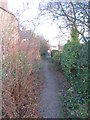
Path to Stagshaw Road
Runs from Corchester Lane.
Image: © Jonathan Thacker
Taken: 30 Nov 2012
0.09 miles
3
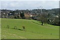
The Tyne Valley north of Corstopitum
Image: © Mike Quinn
Taken: 2 Mar 2013
0.13 miles
6
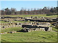
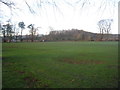
Corstopitum - view of site from southwest corner (3)
See Image
Image: © Mike Quinn
Taken: 2 Mar 2013
0.16 miles
7
Corstopitum - forum/storehouse: east wing
Image: © Mike Quinn
Taken: 2 Mar 2013
0.18 miles
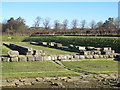
8
Corstopitum - forum/storehouse
See Image The English Heritage guide book says that the "function (of this building) is open to interpretation" - ie no-one really knows what it was for. The building is square with four ranges surrounding a central courtyard; little survives apart from the foundations, and it is now thought that the building was never completed.
Image: © Mike Quinn
Taken: 2 Mar 2013
0.18 miles
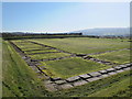
9
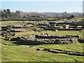
Corstopitum - view of site from southwest corner (2)
See Image
Image: © Mike Quinn
Taken: 2 Mar 2013
0.18 miles
10
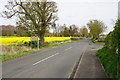
Corchester Lane
Passing the entrance to Corbridge Roman site. The building on the far side of the oil seed rape field is Corchester Towers, which was formerly a preparatory school.
Image: © Bill Boaden
Taken: 18 Apr 2017
0.18 miles