IMAGES TAKEN NEAR TO
Bilberry Way, CORBRIDGE, NE45 5EA
Introduction
This page details the photographs taken nearby to Bilberry Way, NE45 5EA by members of the Geograph project.
The Geograph project started in 2005 with the aim of publishing, organising and preserving representative images for every square kilometre of Great Britain, Ireland and the Isle of Man.

There are currently over 7.5m images from over14,400 individuals and you can help contribute to the project by visiting https://www.geograph.org.uk
Image Map (Loading...)


Getting Data...Please wait
Leaflet Map data © OpenStreetMap
Images are licensed for reuse under creativecommons.org/licenses/by-sa/2.0
Notes
- Clicking on the map will re-center to the selected point.
- The higher the marker number, the further away the image location is from the centre of the postcode.
Image Listing (11 Images Found)
Images are licensed for reuse under creativecommons.org/licenses/by-sa/2.0
Image
Details
Distance
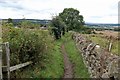
1
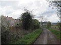
Bridleway towards Corbridge
New housing estate in progress
Image: © Les Hull
Taken: 27 Apr 2016
0.07 miles
2
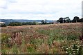
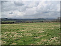
Rough land and arable field west of Deadridge Lane
Once an area of clay pits serving Corbridge Pottery. The remaining kilns of which can be seen in the distance. There were also the quarries and buildings of Corbridge Brick Works which is now a housing estate. The latter was the site of Jameson & Sons Pipe Works, which was once one of the biggest employers in Tynedale and closed in the 1980s. One of the Jameson bricks is shown here: Image
Image: © Andrew Curtis
Taken: 30 Aug 2020
0.08 miles
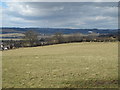
6
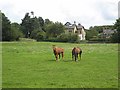
Horses off Milkwell Lane
The large houses asre on Desdridge Lane.
Image: © Oliver Dixon
Taken: 15 Aug 2008
0.19 miles
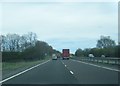
8
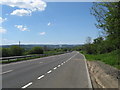
Looking west on the A69
Just outside Coebridge in Northumberland.
Image: © James Denham
Taken: 25 May 2013
0.23 miles
9
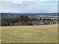
Farmland south of the A69 and the northern outskirts of Corbridge
Image: © Mike Quinn
Taken: 4 Apr 2013
0.23 miles