IMAGES TAKEN NEAR TO
Station Road, CORBRIDGE, NE45 5AX
Introduction
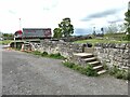
This page details the photographs taken nearby to Station Road, NE45 5AX by members of the Geograph project.
The Geograph project started in 2005 with the aim of publishing, organising and preserving representative images for every square kilometre of Great Britain, Ireland and the Isle of Man.

There are currently over 7.5m images from over14,400 individuals and you can help contribute to the project by visiting https://www.geograph.org.uk
Image Map
Images are licensed for reuse under creativecommons.org/licenses/by-sa/2.0
Notes
- Clicking on the map will re-center to the selected point.
- The higher the marker number, the further away the image location is from the centre of the postcode.
Image Listing (311 Images Found)
Images are licensed for reuse under creativecommons.org/licenses/by-sa/2.0
Image
Details
Distance
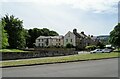
1
Houses at the south end of the Tyne Bridge
Image: © Mike Quinn
Taken: 2 Nov 2009
0.01 miles
2
Filming location near Corbridge Bridge
Numerous vehicles and personnel engaged in the production of "Vera".
Image: © Oliver Dixon
Taken: 29 Jun 2021
0.02 miles
3
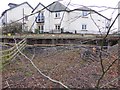
Flood defence wall construction at Corbridge
A substantial flood defence wall is under construction on the south bank of the Tyne east of Corbridge bridge - but despite all, these new defences were overtopped by the floods in December 2015.
Image: © Oliver Dixon
Taken: 17 Dec 2014
0.03 miles
4
Floodwall by the Stanners
Land on the south side of the river is liable to flood. In recent years a massive flood wall has been erected on the north side of the Stanners.
Image: © Oliver Dixon
Taken: 25 May 2021
0.03 miles
5
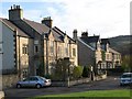
Station Road, Corbridge
This is an outlying part of the town on the south side of the river.
Image: © Robert Graham
Taken: 11 Jul 2022
0.03 miles
6
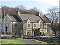
House at the south end of the Tyne Bridge
Formerly a nursing home and then a pub.
Image: © Mike Quinn
Taken: 2 Nov 2009
0.03 miles
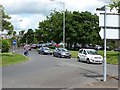
7
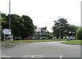
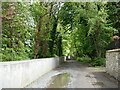
Roundabout on Station Road, Corbridge
On the south side of the River Tyne, just past the bridge.
Image: © Robert Graham
Taken: 11 Jul 2022
0.03 miles
8
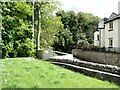
Floodwall by the Stanners
Land on the south side of the river is liable to flood. In recent years a massive flood wall has been erected on the north side of the Stanners. The fence has been installed in an attempt to discourage people from walking along the top of the wall.
Image: © Oliver Dixon
Taken: 25 May 2021
0.03 miles
9
Flood barrier?
Land on the south side of the river is liable to flood. The wall in the foreground affords flood protection additional to the bund behind it. But raising the threshold on the footpath over the wall is a bit of a waste of time considering the unprotected gateway immediately to the left.
The traffic in the background is on the way down from the ancient Corbridge Bridge.
Image: © Oliver Dixon
Taken: 25 May 2021
0.03 miles
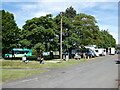
10
Northern approach to the Northumberland County Show
Traffic en route to the hugely popular Northumberland County Show, 2012. Corbridge Bridge was closed to northbound traffic to allow continuous working for show-bound traffic. This is the last occasion on which the Show will be held in Tynedale Park, Corbridge. In future years, the show will be held at Bywell. At least at Corbridge, there is the alternative of public transport by bus or train. At Bywell, there is no such provision, and the pressure on car access is likely to be even more severe.
Image: © Oliver Dixon
Taken: 4 Jun 2012
0.04 miles