IMAGES TAKEN NEAR TO
Batt House Road, STOCKSFIELD, NE43 7QZ
Introduction
This page details the photographs taken nearby to Batt House Road, NE43 7QZ by members of the Geograph project.
The Geograph project started in 2005 with the aim of publishing, organising and preserving representative images for every square kilometre of Great Britain, Ireland and the Isle of Man.

There are currently over 7.5m images from over14,400 individuals and you can help contribute to the project by visiting https://www.geograph.org.uk
Image Map
Images are licensed for reuse under creativecommons.org/licenses/by-sa/2.0
Notes
- Clicking on the map will re-center to the selected point.
- The higher the marker number, the further away the image location is from the centre of the postcode.
Image Listing (5 Images Found)
Images are licensed for reuse under creativecommons.org/licenses/by-sa/2.0
Image
Details
Distance
2
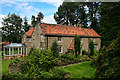
Painshawfield
House in the Painshawfeild estate above Stocksfield.
Image: © Peter McDermott
Taken: 10 Jul 2011
0.12 miles
4
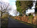
Painshawfield Road
This is the western end of Painshawfield Road, viewed looking east; it's a residential road in the Painshawfield or Park Estate area of the commuter village of Stocksfield. Properties there are mainly large, detached and set in good-sized gardens.
Image: © Trevor Littlewood
Taken: 11 Feb 2019
0.19 miles
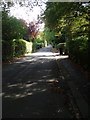
5

Footpath between New Ridley and Painshawfield
Image: © Clive Nicholson
Taken: 16 Feb 2014
0.19 miles