IMAGES TAKEN NEAR TO
Ayton Close, STOCKSFIELD, NE43 7ES
Introduction
This page details the photographs taken nearby to Ayton Close, NE43 7ES by members of the Geograph project.
The Geograph project started in 2005 with the aim of publishing, organising and preserving representative images for every square kilometre of Great Britain, Ireland and the Isle of Man.

There are currently over 7.5m images from over14,400 individuals and you can help contribute to the project by visiting https://www.geograph.org.uk
Image Map
Images are licensed for reuse under creativecommons.org/licenses/by-sa/2.0
Notes
- Clicking on the map will re-center to the selected point.
- The higher the marker number, the further away the image location is from the centre of the postcode.
Image Listing (14 Images Found)
Images are licensed for reuse under creativecommons.org/licenses/by-sa/2.0
Image
Details
Distance
1
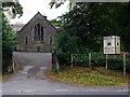
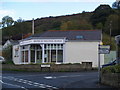
Stocksfield Baptist Church
There is a short account of the history of the Baptist Church in the Tyne valley and in Stocksfield here http://www.stocksfieldbaptistchurch.net/history.shtml
Image: © Andrew Curtis
Taken: 12 Sep 2011
0.14 miles
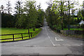
2
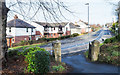
A695 passing through Stocksfield
The A695 heading north-east through the north end of the up-market village; a view from Stocksfield Baptist Church.
Image: © Trevor Littlewood
Taken: 11 Feb 2019
0.16 miles
4
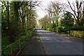
Cade Hill Road
Part of a leafy residential area.
Image: © Bill Boaden
Taken: 21 Apr 2017
0.18 miles
5
Quaker Meeting House
Quaker Meeting House, Branch End, Stocksfield
Image: © Clive Nicholson
Taken: 21 Oct 2006
0.19 miles
6
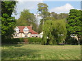
Private green space in Painshawfield
The whole residential area is very green and leafy.
Image: © Bill Boaden
Taken: 21 Apr 2017
0.20 miles
7

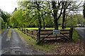
Path from New Ridley Road to High Mickley
Image: © Andrew Curtis
Taken: 12 Sep 2011
0.20 miles
8
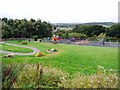
Branch End Play Area
Branch End is part of the parish of Broomley and Stocksfield. The park's toddler area opened in 2006 and was further extended in 2008. The park now incorporates the Stocksfield Community Garden, planted in containers along the curved pathway on the left with plants representing the main senses.
Image: © Andrew Curtis
Taken: 12 Sep 2011
0.20 miles
9
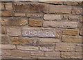
Choc and Dan carved in stone
A long new wall has been built which looks magnificent, I assume Choc and Dan were the constructors of the wall?
Image: © chris whitehouse
Taken: 10 Jul 2013
0.21 miles
10
Apperley Road, Painshawfield
There are still gradients in this residential area below Mickley Common.
Image: © Bill Boaden
Taken: 21 Apr 2017
0.22 miles