IMAGES TAKEN NEAR TO
Castle Road, PRUDHOE, NE42 6PH
Introduction
This page details the photographs taken nearby to Castle Road, NE42 6PH by members of the Geograph project.
The Geograph project started in 2005 with the aim of publishing, organising and preserving representative images for every square kilometre of Great Britain, Ireland and the Isle of Man.

There are currently over 7.5m images from over14,400 individuals and you can help contribute to the project by visiting https://www.geograph.org.uk
Image Map
Images are licensed for reuse under creativecommons.org/licenses/by-sa/2.0
Notes
- Clicking on the map will re-center to the selected point.
- The higher the marker number, the further away the image location is from the centre of the postcode.
Image Listing (12 Images Found)
Images are licensed for reuse under creativecommons.org/licenses/by-sa/2.0
Image
Details
Distance
1
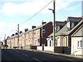
Terraced houses on West Road, Prudhoe
And a couple of semi-detached dormer bungalows.
Image: © Oliver Dixon
Taken: 21 Mar 2019
0.17 miles
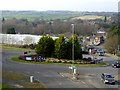
2
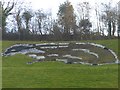
The Prudhoe Badger
Giant earthwork figure cut into the hillside overlooking the Station Road/Prudhoe Bypass roundabout. It was constructed in 1994 to commemorate the opening of the Bypass, but over the following years it fell into disrepair until it was restored by youngsters from the Prince's Trust in 2015. As with other giant hillside figures (notably the White Horses of Wiltshire and elsewhere), it is difficult to get a good undistorted view of the feature.
Image: © Oliver Dixon
Taken: 23 Feb 2019
0.21 miles
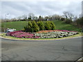
3
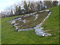
The Prudhoe badger (closeup)
Giant earthwork figure cut into the hillside overlooking the Station Road/Prudhoe Bypass roundabout. It was constructed in 1994 to commemorate the opening of the Bypass, but over the following years it fell into disrepair until it was restored by youngsters from the Prince's Trust in 2015. As with other giant hillside figures (notably the White Horses of Wiltshire and elsewhere), it is difficult to get a good undistorted view of the feature.
Image: © Oliver Dixon
Taken: 23 Feb 2019
0.21 miles
4
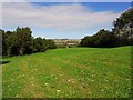
Meadow east of Eltringham Wood
View north-east over the Tyne valley towards Horsley on the far hilltop. This area, now used for public access is a reclaimed spoil tip from the former Eltringham Colliery.
Image: © Andrew Curtis
Taken: 12 Sep 2011
0.21 miles
5
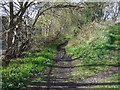
Footpath off the A695
Towards the Tyne Valley.
Image: © JThomas
Taken: 25 Apr 2013
0.22 miles
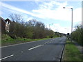
7
Sloping roundabout
A rather intimidating sloping roundabout at the intersection of Station Road with the Prudhoe Bypass (A695). A signal box at the railway crossing can be seen in the middle distance.
Image: © Oliver Dixon
Taken: 23 Feb 2019
0.23 miles
9
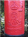
Edward VII postbox near Prudhoe station - royal cipher
See Image
Image: © Mike Quinn
Taken: 21 Oct 2008
0.23 miles
10
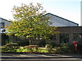
Offices in Station Road
Shows the location of Image
Image: © Mike Quinn
Taken: 21 Oct 2008
0.23 miles