IMAGES TAKEN NEAR TO
PRUDHOE, NE42 5PA
Introduction
This page details the photographs taken nearby to NE42 5PA by members of the Geograph project.
The Geograph project started in 2005 with the aim of publishing, organising and preserving representative images for every square kilometre of Great Britain, Ireland and the Isle of Man.

There are currently over 7.5m images from over14,400 individuals and you can help contribute to the project by visiting https://www.geograph.org.uk
Image Map (Loading...)


Getting Data...Please wait
Leaflet Map data © OpenStreetMap
Images are licensed for reuse under creativecommons.org/licenses/by-sa/2.0
Notes
- Clicking on the map will re-center to the selected point.
- The higher the marker number, the further away the image location is from the centre of the postcode.
Image Listing (9 Images Found)
Images are licensed for reuse under creativecommons.org/licenses/by-sa/2.0
Image
Details
Distance
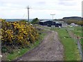
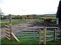
2
Dukeshagg Farm
On the "Engine Road", an ancient byway on the line of an old waggonway which runs north, down from Hedley Hill.
Image: © Oliver Dixon
Taken: 21 Mar 2019
0.01 miles
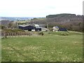
3
Dukeshagg Farm, above Prudhoe
Heddon on the Wall Image can be seen in the distance on the far side of the Tyne.
Image: © Oliver Dixon
Taken: 9 Apr 2007
0.02 miles
4
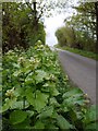
Garlic mustard (Alliaria petiolata), Moor Road
Also known as Jack-by-the-hedge. The genus name, Alliaria, 'resembling Allium', refers to the garlic-like odour of the crushed foliage http://en.wikipedia.org/wiki/Alliaria_petiolata
There is a recipe for rack of lamb with lentils & Jack-by-the-hedge sauce here http://www.bbcgoodfood.com/recipes/2137637/rack-of-lamb-with-lentils-and-jackbythehedge-sauce
Image: © Andrew Curtis
Taken: 5 May 2012
0.03 miles
5
Footpath to Buck's Nook at Dukeshagg Farm
Image: © Andrew Curtis
Taken: 5 May 2012
0.04 miles
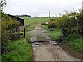
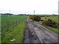
7
Moor Road
The "Engine Road" follows the line of an old waggonway (see Image) down from the crest of the hill en route for the River Tyne and is now a byway. Once past Dukeshagg Farm, it becomes Moor Road, a cul-de-sac tarmac road leading down to Prudhoe.
Image: © Oliver Dixon
Taken: 21 Mar 2019
0.12 miles
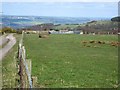
8
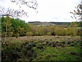
Rough pasture south of Dukeshagg Wood
View towards Guards Wood.
Image: © Andrew Curtis
Taken: 5 May 2012
0.15 miles
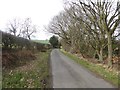
9
Engine Road
The name of this old lane is a reminder of the mining activities of former years. The track partly follows the route of a former wooden waggonway used to take coal from the mines along the ridge of Hedley Fell north then north-east to the River Tyne at Stella near Blaydon http://sites.google.com/site/waggonways/nz/05/nz0560
Image: © Andrew Curtis
Taken: 5 May 2012
0.23 miles