IMAGES TAKEN NEAR TO
Tynedale Close, WYLAM, NE41 8EX
Introduction
This page details the photographs taken nearby to Tynedale Close, NE41 8EX by members of the Geograph project.
The Geograph project started in 2005 with the aim of publishing, organising and preserving representative images for every square kilometre of Great Britain, Ireland and the Isle of Man.

There are currently over 7.5m images from over14,400 individuals and you can help contribute to the project by visiting https://www.geograph.org.uk
Image Map
Images are licensed for reuse under creativecommons.org/licenses/by-sa/2.0
Notes
- Clicking on the map will re-center to the selected point.
- The higher the marker number, the further away the image location is from the centre of the postcode.
Image Listing (60 Images Found)
Images are licensed for reuse under creativecommons.org/licenses/by-sa/2.0
Image
Details
Distance
1
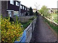
Footpath behind houses on Dene Road, Wylam
As the postman comes this way to deliver mail we can assume that the path is at the front of the houses and the road behind is at their back. They look out onto open fields north of Wylam village.
Image: © Andrew Curtis
Taken: 27 Apr 2018
0.05 miles
3
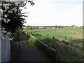
Footpath behind houses on Dene Road, Wylam
The pillbox can be seen in the arable field on the right Image The houses ahead are the rear of Bluebell Close.
Image: © Andrew Curtis
Taken: 27 Apr 2018
0.07 miles
4
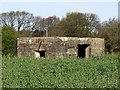
Pillbox north of Wylam village
See description here Image
Image: © Andrew Curtis
Taken: 27 Apr 2018
0.08 miles
5
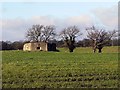
Pillbox north of Wylam village
Concrete World War II pillbox of hexagonal type 22 situated in an arable field north of Wylam village.
Recent photos posted on the internet show that some of the windows are still complete with metal covers.
Image: © Andrew Curtis
Taken: 28 Dec 2011
0.08 miles
6
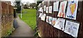
Children's messages of support for the NHS, Engine Dene, Wylam
Use of the rainbow symbol during the Coranavirus outbreak is described here Image
Image: © Andrew Curtis
Taken: 3 Apr 2020
0.10 miles
7
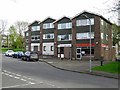
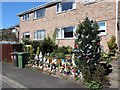
Dene Road, Wylam
Showing the takeaway, Wylam's Garden, and doctors surgery.
Image: © Andrew Curtis
Taken: 27 Apr 2018
0.10 miles
8
Footpath west of Rift Dene, Wylam
There is a description and similar photo here Image
Image: © Andrew Curtis
Taken: 17 Jan 2016
0.12 miles
9
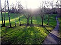
Engine Dene, Wylam
Engine Dene and the adjoining 'Brick Field' were once the site of a clay pit used for brick making in Victorian times. Brick makers were employed by the Blackett estate to manufacture bricks and tiles for use in the village. They were paid the equivalent of 4p for every 100 bricks produced and one man could make about 1000 bricks in a day. The Dene used to run down to the Wylam Iron Works and much of it was left as landscaped open space when the housing estate was built.
Image: © Andrew Curtis
Taken: 28 Dec 2011
0.13 miles
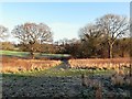
10
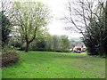
Open space between Jackson Road & The Dene, Wylam
Formerly part of Engine Dene and an industrialised area when Wylam Iron Works was in operation around 1890. The land was not developed when the housing estate was built in the early 1960s.
Image: © Andrew Curtis
Taken: 27 Apr 2018
0.13 miles