
IMAGES TAKEN NEAR TO
WYLAM, NE41 8BL
Introduction
This page details the photographs taken nearby to NE41 8BL by members of the Geograph project.
The Geograph project started in 2005 with the aim of publishing, organising and preserving representative images for every square kilometre of Great Britain, Ireland and the Isle of Man.

There are currently over 7.5m images from over14,400 individuals and you can help contribute to the project by visiting https://www.geograph.org.uk
Image Map
Images are licensed for reuse under creativecommons.org/licenses/by-sa/2.0
Notes
- Clicking on the map will re-center to the selected point.
- The higher the marker number, the further away the image location is from the centre of the postcode.
Image Listing (26 Images Found)
Images are licensed for reuse under creativecommons.org/licenses/by-sa/2.0
Image
Details
Distance
1
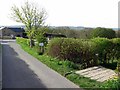
Footpath north of The Rift
The track on the left leads past The Rift Farm and continues south-east to the rear of Stephenson's Cottage. The path on the right has been diverted around the farm cottages, crosses Rift Dene and heads for Wylam.
Image: © Andrew Curtis
Taken: 27 Apr 2018
0.03 miles
2
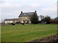
The Rift
The farm takes its name from the nearby Rift Dene, a narrow wooded valley.
Image: © Andrew Curtis
Taken: 29 Dec 2008
0.03 miles
4

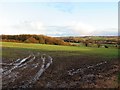
Robin's Pincushion, hedgerow near The Rift
The Robin's Pincushion (also known as the 'Bedeguar Gall') is a gall caused by the larvae of a tiny gall wasp, Dipoloepis rosae. The gall is widespread and common, and can be found developing on the stems of Dog-roses during late summer; it acquires its reddish colour as it matures in autumn. Each gall holds many grubs, which feed on the gall tissues throughout the winter and emerge in spring as adults. The adults reproduce asexually and only a tiny number are male.
https://www.wildlifetrusts.org/wildlife-explorer/galls/robins-pincushion
The countryman's name, Robin's Pincushion, is very old and refers to the woodland sprite, Robin Goodfellow, another name for Puck, the son of Oberon, and the fairies' jester.
https://en.wikipedia.org/wiki/Puck_(folklore)
Image: © Andrew Curtis
Taken: 26 Aug 2018
0.07 miles
6
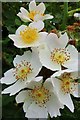
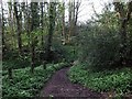
Dog-rose (Rosa canina), The Rift
It is sometimes considered that the word 'dog' has a disparaging meaning in this context, indicating 'worthless' as compared with cultivated garden roses. According to The Oxford Dictionary of Phrase and Fable, the English name is a direct translation of the plant's name from classical Latin, rosa canina, itself a translation of the Greek κυνόροδον ('kunórodon'); the name arose out of the belief in classical times that the root was a cure for the bite of a mad dog. It is known to have been used to treat the bite of rabid dogs in the 18th and 19th centuries. The origin of its name may be related to the hooked prickles on the plant that have resemblance to a dog's canines.
https://en.wikipedia.org/wiki/Rosa_canina
Image: © Andrew Curtis
Taken: 26 Jun 2020
0.09 miles

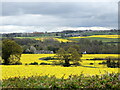
9
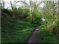
Site of Hope Pit
See description here Image
Photo taken on footpath west of Rift Dene in opposite direction to that shown here Image
Image: © Andrew Curtis
Taken: 27 Apr 2018
0.14 miles
10
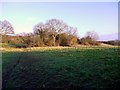
Site of the disused Hope Pit
The scrub woodland conceals foundations of buildings (mine engine houses and Rift Cottages), a spoil heap, and (on the right) the start of a waggonway which led due south towards North Wylam Railway Station. Hope Pit was known locally as 'Chuckee Pit' and was worked periodically during the C18th and C19th, although finally closed in 1893-94.
Image: © Andrew Curtis
Taken: 28 Dec 2011
0.14 miles